Brackloon
Extract from Townlands chapter in Killererin - A Parish History

Brackloon, Breac-chluain, Bhreac-chluana “speckled pasture”[1]
The townland of Brackloon is located in the Civil Parish of Killererin. The townland is located in the south-west of the parish and is bordered on the north by the townland of Gortbeg, in the south by Brooklodge, in the west by another townland also called Brackloon and in the east by Ballina and Ballynapark. The Down Survey, a mapping survey carried out between 1656 and 1658 records the townland as ‘Doonmoylin’[2]. In Brackloon in 1641, the owners were listed as ‘Richard Bourke (Catholic)’ and in 1670 ‘Ambrose Bodkin (Catholic)’ and there were 53 plantation acres of unprofitable land, 84 plantation acres of profitable land and 84 plantation acres forfeited[3].
O’Donovan’s Field Names Books of 1830
According to O’Donovan’s Field Names Books of 1830[4] early references to the townland were given as ‘Bricklon’ and ‘Brackluon’ found in the Chancery Inquisitions of King James I (1603-1625) and ‘Breakloone’ in the Chancery Inquisitions of King Charles 1 (1625-1649)[5]. Mention is also made of ‘Brackloon’ in The Boundary Survey Sketch Maps completed during the field names survey (which began in 1824) and officiated by John O’Donovan (1806-1861) and others[6]also cite Thomas Gilmore, Proprietor’s Tenant as an ‘authority source’ on the established spelling of ‘Brackloon’[7]. The townland is described as ‘the property of Mr. Skerritt, Ballinduff. It contains 83½ acres statute[8] measure, all arable land’[9]. Today, locally, the townland is spelled ‘Brackloon’.
Census 1841-1851[10]
There were 64 people living in Brackloon in 1841 in 11 households. In 1851 the number of residences was dramatically reduced to 28 people living in just 6 households. The Poor Law Valuation of Brackloon in 1851 was £24 0s 0d.
Griffith’s Valuation 1855[11]
There are 7 occupiers of land listed on Griffith’s Valuation in 1855. All of the landholders leased their land from the Trustees of Dominick D. Skerritt with the exception of Dominick Donnellan who held land leased from both Skerritt and Martin J. Blake, from the former, an area of 22 acres, 3 roods and 25 perches and the latter 4 acres 0 roods and 6 perches. Patrick Morris also leased land from Blake amounting to 2 acres, 0 roods and 34 perches. During this time Brooklodge, near Ballyglunin, located to the south of Brackloon, was Skerritt property and leased by the Blake’s[12].
Other Lessees of Skerritt Trustees
The remaining tenants who leased land from the Skerritt Trustees included; James Banne who held land measuring 14 acres, 0 roods and 15 perches; Patrick Delany held a house and land measuring 6 acres, 3 roods and 35 perches; John Delany held a house and land measuring 13 acres, 0 roods and 35 perches; Thomas Banne leased a house and land measuring 11 aces, 0 roods and 20 perches while Michael J. Blake also leased land from the Skerritt Trustees amounting to 9 acres, 0 roods and 20 perches.
Land owned by the Skerrit family in the area
In the 1870s the Skerritt family owned 3,733 acres in county Galway[13]. The trustees of Dominick D. Skerritt also owned most of the land in Ballina, Cloonlusk and Gortbeg[14]. The total area of land valued in the townland of Brackloon was 83 acres, 2 roods and 20 perches. The largest holding with a herd’s house, land and offices was held by Dominick Donnellan mentioned above and the smallest holding was held by a Patrick Morris. The total valuation of land was £29 15s. 0d.
Census 1861-1881[15]
By 1861 there were 37 people living in the townland in 7 households; in 1871 a total of 34 people lived in 6 households and in 1881, 45 people lived in 8 households. The valuation of land and houses in Brackloon in 1881 was £35 6s 0d.
Census 1891[16]
There were 31 people living in 7 households in Brackloon in 1891.
The 1901 Census[17]
There are 69 people recorded on the 1901 Census including the Bane, Burke, Delaney, Mannion, Forde, McNamara, Howley, Kelly, Malia, McCabe, Kelly and Mullen families.
Michael Bane
Aged 68, a farmer was married to Bridget aged 56. Michael and Bridget had a son John aged 22, who was a blacksmith.
Patrick Forde
Aged 52, was married to Margaret aged 45. They lived with their children: Martin aged 12, Ellen aged 17 and Bridget aged 18.
Patrick Howley
Aged 42 was married to Kate also aged 42.They lived with their children: Julia, aged 10 and Mary aged 4.
John Burke
Was aged 64 and was married to Bridget aged 50. They lived with their children: John aged 24, Patrick aged 17, Kathleen aged 19 and ‘Mally’ aged 16.
John McCabe
Aged 58 was a widower. John lived with his children: John aged 28, Charles aged 23, Delia aged 18 and Sarah aged 12.
Matt Bane
Aged 40 was married to Honor aged 32. They lived with their children: Julia aged 9, Mary aged 7, Michael aged 6, Bridget aged 4, Kate aged 2 and a baby named Norah.
Patrick Mannion
Was aged 92. Patrick was married to Mary aged 62. This home also included the Dolan family. Patrick’s daughter Margaret aged 28 was married to John Dolan aged 33. Margaret and John had 6 children in 1901: Ellen, aged 7, Patrick aged 5, Michael Thomas aged 4, John Francis aged 3, William aged 1 and a baby named James.
Michael Mullen
Aged 39 was married to Sarah aged 37. They lived with their children: Andrew aged 9, Mary aged 7, Margaret aged 5, Ellen aged 4 and Patrick aged 1.
Mary McNamara
Was aged 72 and a widow. She lived with her daughter, Delia Gorman aged 35 and grandchildren: Mary E. aged 16, Kathleen aged 14, Norah aged 12, Sarah J. aged 11, Patrick aged 10, Harriett aged 8 and a baby named Joseph. A boarder, Mary Ellen McHugh aged 23 also lived in this house.
Michael Delaney
Aged 81 was head of the family and lived with his wife Margaret aged 78. There were no other people listed in this house in 1901.
James Malia
Was head of the family aged 27 and married to Sarah aged 20. There were no other people listed in this house in 1901 either.
Mary Kelly
Was aged 50 and a widow. She lived with her children: James aged 18 and Patrick aged 16.
John Delaney
Aged 27 was unmarried. John lived with his mother, Margaret aged 60 and his sister, Katie aged 18.
Anne Greaney
Was aged 78 and a widow. Anne is listed on her own in this house.
Occupations
The majority of occupations are listed as ‘scholar’ or ‘farmer’ with the exception of Anne Greaney aged 78, a wool spinner; Mary Ellen McHugh aged 23, a national teacher and Michael Bane aged 68 years and his son John aged 22, both blacksmiths. Bane’s Forge is recorded on the out-buildings returns for the townland.
All of the families listed in 1901 had a cowhouse, piggery and fowl-house. The property where John Delaney resided also included a stable.
Oldest and Youngest persons in 1901
In 1901 the oldest person in the townland was Patrick Mannion, a farmer aged 92 years from Co. Galway. Patrick could not read or write. The youngest people in the townland in 1901 were Norah Bane, Joseph Gorman and James Dolan who were not yet 1 year old.
1911 Census[18]
There are 83 people listed on the 1911 census and again many of the occupations are recorded as farmers or farm labourers. The heads of household included Robert Burke, Patrick Howley, Bridget Bane, Mary McNamara, James Melia, Patrick Ford, John Delaney, John McCabe, John Dolan, John Graney, Mary Kelly, Matt Bane, Michael Mullin and William Walsh.
Matt Bane
Was married to Norah and lived with their children: Mary aged 18, Michael aged 17, Delia aged 15, Kathleen aged 13, Norah aged 10 and Sabina aged 9. A 19-year old daughter, named Julia, is crossed out of the census returns. Matt and Norah were married for 21 years and had 8 children with 7 still living in 1911.
Bridget Bane
Aged 70 and a widow lived with her son, John aged 32.
Bridget Burke
Aged 66, was a widow. Bridget lived with her children: Patrick aged 26, Bedelia aged 23 and John aged 30 and her grandchildren: Joe aged 16, Martin aged 14 and Frances aged 15. There are no parents listed for the grandchildren in this census.
John Delaney
Aged 40, was married to Norah aged 43. They lived with their children: Thomas aged 8, John aged 6, Bernard aged 4 and Patrick aged 1. Margaret Delaney aged 73, who was John’s mother, also lived in this house. John and Norah were married for 10 years and had 4 children with 4 still living in 1911.
John Dolan
Aged 47 was married to Margaret aged 39. They lived with their children: Ellen aged 16, Patrick aged 15, Michael G. aged 13, John G. aged 10, William aged 9, James, aged 8, Mary K, aged 7, Joseph aged 6, Maggie D. aged 5, Sabina aged 3 and a baby named Nora. John and Margaret were married for 17 years and they had 12 children with 11 still living in 1911.
Patrick Ford 72
Was married to Margaret aged 65. They lived with their children: Bridget aged 30, Ellie aged 27, Catherine aged 25 and Martin aged 23. Patrick and Margaret were married for 30 years and had 4 children with 4 still living in 1911.
Anne Greaney
A widow, is listed as living alone on the census, aged 78.
Patrick Howley
Aged 52, was married to Kate aged 56. They lived with their children: Julia aged 20 and Mary, aged 15. Patrick and Kate were married for 24 years and they had 4 children with 2 still living in 1911.
Mary Kelly
Aged 70 was a widow. She lived with her son, Pat aged 31.
Mary McNamara
Aged 87 was also a widow. She lived with her family: daughter-in-law Delia Gorman aged 50 and grandchildren: Patrick aged 20 and Joseph aged 10. Delia Gorman was married 27 years and had 7 children with 7 still living in 1911.
John McCabe
Aged 70 was a widower. John lived with his children: John aged 42, Charles aged 32 and Sara aged 28.
James Malia
Aged 40 was married to Mary aged 30. They lived with their children: Michael aged 9, Patrick aged 7, Martin aged 3 and Mary aged 1. James’ sister-in-law Nora aged 23 and James’ nephew, Michael Farragher were also listed in this house. James and Mary were married for 10 years and had 4 children with 4 still living in 1911.
Michael Mullin
Aged 60 was married to Sarah aged 49. They lived with their children: Andrew aged 19, Mollie aged 17, Margaret aged 16, Ellen aged 14, Patrick aged 11, Peter aged 9 and Michael aged 6. Michael and Sarah were married for 20 years and had 7 children with 7 still living in 1911.
William Walsh
Aged 53 was married to Bridget also aged 53. They lived with their children: Mary Bridget Whitman aged 22, William Walsh aged 17 and Michael Walsh aged 13. William’s grandaughter, Mary aged 1 was also listed in this house. William and Bridget were married for 23 years and had 7 children with 6 still living in
1911
As in 1901, farming as an occupation is reflected in the number and type of out-buildings listed by the enumerator including cowhouses, piggeries and sheds. The Bane’s forge is not listed on the 1911 census as it was in 1901. Outside of farming, other occupations recorded included Andrew Mullin and William Walsh listed as postmen.
Place of Birth
As with other townlands, the majority of families list their place of birth as Galway. The exception to this in Brackloon was William Walsh who listed his place of birth as Co. Waterford.
Oldest and Youngest persons in 1911
The oldest person in the townland was Mary McNamara aged 87 and the youngest were Nora Dolan and Michael Farragher who were less than 1 year old.
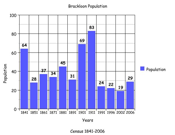
Census 1991-2006
The bar graph accompanying this article plots the changes in population in this townland between 1841 and 2006 according to census information.[19]
Mapping Change
A comparison between the OS 25 inch Map produced 1888-1913[20] and the OS Aerial map 2005, gives a good indication of the changes in the landscape and geography of the townland. The early map shows the townland divided between two parishes, Killererin and Kilmoylan. The Killererin portion of the townland is a long, narrow strip of land with a small forested area in the south. A small area to the southwest of this was recorded as liable to flooding. In the northeast, a lime kiln was in operation and a number of others were recorded on the border with the large neighbouring townland of Ballina. A forge was also recorded on the border here too.
According to the later 2005 Arial Map some minor changes have taken place in the landscape. In the southwest of the townland, a quarry works has been developed and seems to straddle both parishes. Between 2000 and 2005 an extensive amount of work had taken place at this site and an extension of the quarry works had also taken place in its south-western edge into Kilmoylan. Much of the land in this townland has been retained as farmland.
[1] Placenames Database, (http://www.logainm.ie/Viewer.aspx?text=Brackloon&streets=yes) (Jan 2011)
[2] Trinity College, Dublin, ‘The Down Survey’ (http://downsurvey.tcd.ie/landowners.php#mc=53.519656,-8.805316&z=14) (22 May 2013)
[3] ibid
[4] Galway County Library, ‘O Donovan’s Field Names Books’ (www.places.galwaylibrary.ie/asp/valuation) (Mar 2011)
[5] Longford County Library, (www.longfordlibrary.ie/placenames) (Mar 2011)
[6] Galway County Library, ‘O’Donovan’s Field Name Books’(http://places.galwaylibrary.ie/asp/fullresult.asp?id=26080) (Apr 2011)
[7] Galway County Library, ‘O Donovan’s Field Name Books’(http://places.galwaylibrary.ie/asp/fullresult.asp?id=26080) (Mar 2011)
[8]PODUNK ‘Place Types and Land Allocation in Ireland’ (http://ei.epodunk.com/place-types.html) (June 2011) An Irish acre, the measure used from the 17th century, equalled 1.62 statute (English) acres, also called a plantation acre
[9] Galway County Library, ‘O’Donovan’s Field Name Books’(http://places.galwaylibrary.ie/asp/fullresult.asp?id=26080) (May 2011)
[10] ‘Table VII –Area, Out-offices and Farm Steadings and Population together with the Valuation of Each Parish, Townland and Township of the County of Galway in 1881’ (James Hardiman Library, National University of Ireland, Galway, pps. 38)
[11] Ask about Ireland, ‘Griffith’s Valuation’ (http://www.askaboutireland.ie/griffith-valuation (Feb 2011)
[12] National University of Ireland, Galway, ‘Landed Estates Database’ (http://landedestates.nuigalway.ie) (Mar 2011)
[13] National University of Ireland, Galway, ‘Landed Estates Database’ (http://landedestates.nuigalway.ie) (Mar 2011)
[14] Galway County Library, ‘O Donovan’s Place Name Books’ (www.places.galwaylibrary.ie/asp/valuation) (Mar 2011)
[15] ‘Table VII –Area, Out-offices and Farm Steadings and Population together with the Valuation of Each Parish, Townland and Township of the County of Galway in 1881’ (James Hardiman Library, National University of Ireland, Galway, pps. 38)
[16] Census of Ireland for the Year 1911 [Province of Connaught, County of Galway] Area, Houses and Population, ‘Table VII-Area Houses Out-Buildings and Farm Steadings, and Population together with the Valuation of Each Poor Law Union, Dispensary District, Electoral Division, Townland in the County of Galway in 1911’ (Galway County Library, p110)
[17] The National Archives of Ireland, ‘Census Ireland 1901/1911’, (http://www.census.nationalarchives.ie/search/results.jsp?census_year=1901&surname=&firstname=&county=Galway&townland=Brackloon&ded=&age=&sex=&search=Search&relationToHead=&religion=&education=&occupation=&marriageStatus=&birthplace=&language=&deafdumb=&marriageYears=&childrenBorn=&childrenLiving=) (Apr 2011)
[18] National Archives of Ireland, ‘Census of 1911’ (http://www.census.nationalarchives.ie/search/results.jsp?census_year=1911&surname=&firstname=&county=Galway&townland=Brackloon&ded=&age=&sex=&search=Search&relationToHead=&religion=&education=&occupation=&marriageStatus=&birthplace=&language=&deafdumb=&marriageYears=&childrenBorn=&childrenLiving=) (Apr 2011)
[19] Kids Zone Learning with NECS ‘Create a Graph’, (http://nces.ed.gov/nceskids/createagraph/default.aspx?ID=6a334b2bea6040ee8a7a6a409af127d8) (Feb 2012)
[20] Ordnance Survey Ireland, ‘25” Historical Map 1888-1913’ (www.osi.ie/publicviewer) (Apr 2011)


No Comments
Add a comment about this page