Brooklodge
Extract from Townlands chapter, Killererin - A Parish History
Extract from chapter in Killererin - A Parish History


Brooklodge Demesne, Cúl Feabhair,[1] “corner, nook of the spring or well”[2]
The townland of Brooklodge is situated in the Civil Parish of Killererin in the Barony of Clare. The townland is bordered on the north by Ballynapark, in the south by the townland of Ballyglooneen, and in the east by Coolfowerbeg and in the west by the townland of Ardskea Beg, in a neighbouring parish. The Down Survey, a mapping survey carried out between 1656 and 1658 records the townland as ‘Castlemoyle’[3]. In Brooklodge in 1641, the owners were listed as ‘Patrick Darcy (Catholic)’ and in 1670 ‘Thomas Deane (Protestant)’ and there were 25 plantation acres of unprofitable land, 85 plantation acres of profitable land and 85 plantation acres forfeited[4].
O’Donovan’s Field Name Books 1830
According to O’Donovan’s Field Name Books 1830[5] the townland of ‘Brooklodge’ is mentioned in William Larkin’s County Map of Galway 1819. The Boundary Survey Sketch Maps completed during the field names survey (which began in 1824) and officiated by John O’Donovan (1806-1861) and others[6], cited the spelling of the townland as ‘Brooklodge Demesne’. The Pettigrew and Oultan, Dublin Almanac and General Register of Ireland 1835, a general register of all officials and administrative offices in Ireland, including fairs, the postal service, the legal establishment, banks, colleges, railways, and listings of all officials for every county and town in Ireland, cited ‘Brook Lodge’ in its listings. Thomas Gilmore, Proprietor’s Tenant is also referred to as an ‘authority source’ on the spelling of the townland as ‘Brooklodge’. Today, locally, the townland is spelled, ‘Brooklodge Demesne’.
Description of Townland
The townland is described as the property of Martin Blake and contained 204 acres, 2 roods and 20 perches ‘statute[7] measure including a large area of plantation and some arable land.[8] Blake owned land in other parts of the parish including Cloondahamper, Coolfowerbeg and Ballynapark.
Census 1841-1851[9]
There were 8 people living in 2 houses in the townland in 1841 and this population decreased to 7 people living in 1 house in 1851. The total area of land measured 204 acres, 1 rood and 7 perches with an annual valuation of £105 0s 0d.
Griffith’s Valuation 1855[10]
All of the land on which the houses were built was owned by Robert Blake although Blake doesn’t seem to have been resident there at that time. John Kennedy and Timothy Nally lived in 2nd class houses and in the Kennedy house 5 people lived in 4 rooms. In the Nally house, 4 people lived in 4 available rooms. James Conaty, the game keeper lived in a 1st class house. In this house James lived alone occupying 2 rooms. This house had 12 front windows and was constructed from stone with a slate roof and so was probably Brooklodge House.
Occupants of Townland 1855
There was only 1 occupier of land in Brooklodge in 1855. Martin J. Blake leased a house, offices and land from the Trustees of Dominick D. Skerritt measuring 204 acres, 1 rood and 27 perches at an annual value of £125 0s 0d. In the 1830s the land in this townland belonged to the Blake Family. Brooklodge, near Ballyglunin, was Skerritt property during 1855 but was held by the Blake’s of Ballyglunin on a lease dated 1775[11]. This may explain how this land in 1855 was held by Blake.
Census 1861-1881[12]
There were 3 people living in 2 houses in Brooklodge in 1861 and this population increased to 18 people in 3 houses in 1871 and 16 people living in 5 houses in 1881. The total area of land in the townland in 1881 was 204 acres, 1 rood and 47 perches with an annual valuation of £90 0s 0d. There were 16 out-buildings listed in 1881 and 1 uninhabited building.
Census 1891[13]
There were 13 people living in 3 houses in Brooklodge in 1891.
Census 1901[14]
There were 10 people living in 3 houses in the townland in 1901.
John Kennedy,
Head of family aged 56 was married to Mary aged 55. John and Mary lived with their children: Michael aged 22, John aged 18 and Mary aged 15.
Timothy Nally
Aged 34 was married to Mary aged 24. They lived with their son, James F. aged 1 year. Timothy’s mother, Anne aged 70, also lived in this house.
James Conaty
Aged 34 was unmarried and lived alone. James Conaty was a gamekeeper. There were a number of out-buildings also listed by James Conaty, including 4 stables, a coach house, harness room, 2 cow houses, a piggery, a fowl house, boiling house, turf house, shed and laundry.
All of those listed recorded their place of birth as ‘Galway’ with the exception of James Conaty, who was from Co. Cavan and Anne Nally who was from Co. Mayo. There were no farmers listed in this townland.
Timothy Nally
Was a shepherd;
Mary Kennedy
Was a housekeeper;
John Kennedy
Was a postmaster;
Michael and John Kennedy
Were carpenters. Both the Kennedy and Nally houses had 4 front windows and between them they had 7 outhouses. Both listed a cowhouse, piggery and fowl house while John Kennedy also held a stable.
Youngest and oldest persons in townland
The youngest person in the townland in 1901 was James Nally, aged 1 year and the oldest was Anne Nally, aged 70.
Census 1911[15]
The same 3 families recorded in 1901 census were listed in the 1911 census.
John Kennedy aged 68 was married to Mary aged 67. John and Mary lived with their children: John aged 27 and Mary Ellen aged 24. They were married for 38 years and had 6 children with 3 still alive in 1911.
James Conaty aged 32 was married to Maggie. James and Maggie lived with their children: Bernard Maurice aged 7, Mary Ellen aged 5 and John James aged 1. They were married for 10 years and had 4 children with 3 still living in 1911.
Thady Nally was listed as head of the Nally family in 1911. Thady was aged 45 years and he was married to Mary aged 34. They lived with their children: Jemmie aged 11, Paddy aged 9, Timothy aged 7, Michael aged 5 and Martin aged 3. They were married for 12 years and had 6 children and 5 still living in 1911.
Place of Birth
All those recorded, listed their place of birth as Galway, with the exception of James Conaty from Co. Cavan and Maggie Conaty from Co. Waterford. Other occupations recorded in the townland included: Thady Nally, who was a shepherd and Mary Ellen Kenney, a telegraphist.
1911
As in 1901, all of the land on which the houses in the townland were situated was owned by Robert Blake. In 1911 all of the houses were 2nd class. Thady Nally’s house had 5 front windows, John Kennedy’s had 5 windows and James Conaty’s had 4 windows. All of the houses had a stable, piggery and fowl house while James Conaty also listed a barn, turf-house, shed and potato-house. The youngest person in the townland in 1911 was John James Conaty aged 1 and the oldest person was John Kennedy aged 68.
Census 1991-2006
The bar graph accompanying this article, plots the changes in population in this townland between 1841 and 2006 according to census information[16].
Mapping Change
The Ordnance Survey (OS) Maps (1837-1842)[17] show that the townland of Brooklodge is triangular in shape and bordered entirely on the south by the Abbert River[18]. Along this southern border, a waterfall was located and the map also refers to a ‘line of inundation’. At the southern-most point, to the west of the waterfall a Roman Catholic chapel and schoolhouse were located. Slightly further north of the chapel was Brooklodge House itself surrounded on its western side by planted garden and forestry.
NUIG Landed Estates Database
According to NUIG Landed Estates Database, Brooklodge ‘was leased to Christopher French by Ambrose Deane on 16 June 1775 for 1 life and 99 years. He built a house which later became a Blake residence held from the trustees of Dominick D. Skerritt, who had inherited it from the Deanes’[19].
Griffiths Valuation 1855
Griffith’s Valuation, 1855 indicates that Martin J. Blake leased the house, out-offices and land from the trustees of the Dominick D. Skerritt estate.
National Inventory of Architectural Heritage
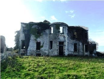
The National Inventory of Architectural Heritage describes Brooklodge House as a ‘detached five-bay, two-storey country house, built c.1770, with a half-basement, bow-fronted entrance bay and having slightly projecting end bays. There was a four-bay, single-storey wing to the northwest with half-basement and stone chimney-stack, and two-storey projecting bay with semi-basement to the southwest. It is now in ruins and partly covered in ivy’[20]. This inventory, that aims to identify and record the architectural heritage of Ireland from 1700 to the present day states that this building sits as a centrepiece of other important structures in the landscape including the ice house and chapel built in a gothic style. All of these buildings give a very clear indication of the type of lifestyle enjoyed by those living in the house.
On the eastern side of the house, a canal ran dividing the house and its grounds from the heavily forested areas at the centre and northern parts of the townland. To the northwest of the house an ice house was situated. The ice house, now largely in ruins was built in approximately 1770 as a modern day refrigerator, allowing food to be kept fresh for the family in Brook Lodge[21]. On the northern side of the canal close to the forested area, a small circular grove of trees stood. a trigonometrical point was situated near the northern-most tip of Brooklodge
Post Office
A road leading from the ice house and Brook Lodge led to a small junction, where a building was located. This building is possibly the Post Office at Ballyglunin and it is also shown on the later 1881-1913 map facing the townland of Coolfowerbeg across the road, an area historically liable to flooding. The Post Office is still in operation today.
Maps
A comparison between the 25 inch map 1888-1913 and the Aerial 2005 map,[22] shows how the landscape and geography of the area has largely remained the same. The 1888-1913 map shows an infant’s burial ground located just outside Brooklodge on the border with Coolfowerbeg. In the west of the townland, the Pallas Bridge spans the Abbert River from Brooklodge into Pollawarla in the east. The Bridge was built in approximately 1880, probably from stone from an older bridge dating from approximately 1800. The bridge was constructed from limestone with 5 arches[23]. Another bridge carried the Demesne Road across the River Abbert and this single arch structure was built in approximately 1770[24]. Much of the northern portion of the townland continued to be covered with forestry as shown in the earlier 1842 map. Brooklodge House, the Chapel, school buildings and the ice house were also indicated on the later map.
The Aerial map 2005 shows that a portion of the north of Brooklodge is still forested as are small parts of the south. Brooklodge House is surrounded by green fields and the house itself is in ruins. The northernmost part of the townland is being used as a quarry. According to the Street map, Ballyglunin Post Office is situated within the townland of Brooklodge near a small junction. Heading south at this junction leads past a new housing development along a narrow road into Brooklodge Nursing Home.
[1] Logainm.ie, ‘Placenames Database of Ireland’ (http://www.logainm.ie/Viewer.aspx?text=Brooklodge+Demesne&streets=yes) (May 2011)
[2] ibid
[3] Trinity College, Dublin, ‘The Down Survey’ (http://downsurvey.tcd.ie/landowners.php#mc=53.519656,-8.805316&z=14) (22 May 2013)
[4] ibid
[5] Galway County Library, O’Donovan’s Field Name Books’(http://places.galwaylibrary.ie/asp/fullresult.asp?id=26089) (Sep 2011)
[6] Galway County Library, O’Donovan’s Field Name Books’(http://places.galwaylibrary.ie/asp/fullresult.asp?id=26089) (Sep 2011)
[7] PODUNK ‘Place Types and Land Allocation in Ireland’ (http://ei.epodunk.com/place-types.html) (June 2011) An Irish acre, the measure used from the 17th century, equalled 1.62 statute (English) acres, also called a plantation acre
[8] Galway County Library, O’Donovan’s Field Name Books’(http://places.galwaylibrary.ie/asp/fullresult.asp?id=26089) (Sep 2011)
[9] ‘Table VII –Area, Out-offices and Farm Steadings and Population together with the Valuation of Each Parish, Townland and Township of the County of Galway in 1881’ (James Hardiman Library, National University of Ireland, Galway, p20)
[10] Ask about Ireland, ‘Griffith’s Valuation’ (http://www.askaboutireland.ie/griffith-valuation/index) (Sep 2011)
[11] National University of Ireland, ‘Landed Estates Database (www.landedestates.ie)_ (Mar 2012)
[12] ‘Table VII –Area, Out-offices and Farm Steadings and Population together with the Valuation of Each Parish, Townland and Township of the County of Galway in 1881’ (James Hardiman Library, National University of Ireland, Galway, p38)
[13] Census of Ireland for the Year 1911 [Province of Connaught, County of Galway] Area, Houses and Population, ‘Table VII-Area Houses Out-Buildings and Farm Steadings, and Population together with the Valuation of Each Poor Law Union, Dispensary District, Electoral Division, Townland in the County of Galway in 1911’ (Galway County Library, p110)
[14] The National Archives of Ireland, ‘Census of Ireland 1901/1911’ (http://www.census.nationalarchives.ie/search/results.jsp?) (Sep 2011)
[15] ibid
[16] Kids Zone Learning with NECS ‘Create a Graph’, (http://nces.ed.gov/nceskids/createagraph/default.aspx?ID=6a334b2bea6040ee8a7a6a409af127d8) (Feb 2012)
[17] Ordnance Survey Ireland, ‘25” Historical Map 1888-1913’ (www.osi.ie/publicviewer) (Sep 2011)
[18] National Inventory of Architecture, ‘Buildings of Ireland’ (www.buildingsofIreland.ie) (Sep 2011)
[19] National University of Ireland, Galway, ‘Landed Estates Database’ (www.landedestates.ie) (Sep 2011)
[20] ibid
[21] National Inventory of Architecture, ‘Buildings of Ireland’ (www.buildingsofIreland.ie) (Sep 2011)
[22] Ordnance Survey Ireland, ‘25” Historical Map 1888-1913’ (www.osi.ie/publicviewer) (Sep 2011)
[23] National Inventory of Architecture, ‘Buildings of Ireland’ (www.buildingsofIreland.ie) (Sep 2011)
[24] ibid


No Comments
Add a comment about this page