Coolreagh/Coolrevagh


Townland of Coolrevagh
Location
The townland of Coolrevagh is situated in the Civil Parish of Killererin in the Barony of Clare. The townland is bordered on the north by Grange, in the south by the townland of Cahergal, in the east by Garraun and in the west by the townland of Toghermore. The Down Survey, records the townland as ‘Crevagh’[1]. In Coolrevagh in 1641 and in 1670, the owners were listed the ‘Earl of Clanrickard’. There were 106 plantation acres of unprofitable land and 175 plantation acres of profitable land[2].
O’Donovan Field Name Books
According to O’Donovan’s Field Name Books 1830[3], early references to ‘Cowlreogh’ were found in the Chancery Inquisitions of Elizabeth I (1558-1603) and to ‘Coolereogh’, ‘Culereagh’ and ‘Coulreagh’ in the Chancery Inquisitions of James I (1603-1625). Reference is also made to ‘Coolrevagh’ in the Map of Property sin 1813 and 1814 and to ‘Coolrevagh’ in the Boundary Survey Sketch Maps[4]. Today locally, the townland is spelled ‘Coolreagh’.
Landlord Hugh R. Henry
The townland is described as the property of H.R. Henry, Esquire of England and contained 292¾ acres statute[5] measure including about 135 acres of arable land.[6] H.R. Henry also owned land in other parts of the parish including Addergoole, Ballynakilla, Barnaderg, Cloonconra, Cloonreddia, Cooldorragha, Carrowgorm, Cornacartan, Corralea, Corskeaghmore, Corskeaghbeg, Creevaghbaun, Grange, Killeighter, Kilmore, Lisnaminaun, Lissavalley and Lissavalley Glebe.
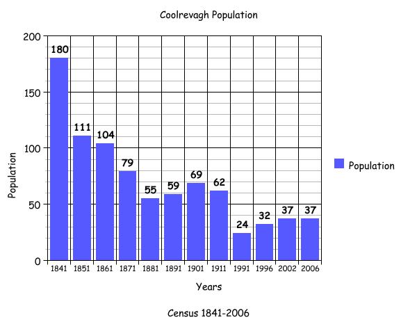
Census 1841-1851[7]
There were 29 houses and 180 people living in Coolrevagh in 1841 and this population decreased in 1851 to 111 people living in 17 houses. The total area of land in the townland was 293 acres, 3 roods and 36 perches with an annual valuation of £74 0s 0d. There were no uninhabited buildings in the townland in 1841.
Griffith’s Valuation 1855[8]
Most of the land in this large townland was leased from Hugh Henry, with the exception of a house and land retained by Henry himself amounting to 62 acres, 1 rood and 0 perches and an area consisting of 22 acres, 1 rood and 10 perches leased by Patrick Hughes from Edmund McHugh. This plot contained a house, out-offices and land. Others who occupied and leased land in Coolrevagh included Michael Coleman, Edmund Coleman, James Ward, Patrick Hughes, Michael Farrell, Hugh Henry, Thomas Kelly, Henry Tighe, John Dunleavey, Thomas Stephens, Patrick Nolan, Patrick Hughes, Patrick Nolan, Thomas Kelly, and William Laffey.
The largest amount of land (outside of the 62 acres held by Hugh Henry) was held amongst Patrick Hughes, James Ward, Patrick Nolan, John Dunleavy, James Hughes, Thomas Kelly, Thomas Stephens, William Laffey and Henry Tighe amounting to 48 acres, 3 roods and 22 perches. A 2nd large holding was held among Thomas Kelly, James Hughes, Henry Tighe, William Laffey and John Dunleavy including houses, out-offices and land amounting to 37 acres, 3 roods and 19 perches. The smallest amount of land was occupied by Michael Coleman and included a house and land measuring 2 acres, 1 rood and 15 perches.
Census 1861-1881[9]
There were 17 houses and 104 people living in Coolrevagh in 1861 and this population decreased to 79 people living in 12 houses. By 1881 there were 13 inhabited houses and a population of 55 people with 1 uninhabited house in the townland. There were 31 out-buildings listed in the townland in 1881. The total amount of land in the townland in 1881 was 293 acres, 3 roods and 36 perches with an annual valuation of £116 8s 0d.
Census 1891[10]
In 1891 there were 12 houses listed on the census with a population of 59 people.
Census 1901[11]
There were 12 heads of family listed in Coolrevagh in 1901.
Honor Coleman was a widow, aged 60. Honor lived with her son Michael aged 36, daughter-in-law Honor aged 30 and her grandchildren: Mary aged 5, Bridget aged 2 and Walter who was less than 1 year old.
Patrick Tighe aged 48 was married to Ellen aged 46. They lived with their children: Michael aged 16, Mary aged 10, Ann aged 8, Margaret aged 6, Ellen aged 4 and Kate aged 2.
Thomas Stephens aged 50 was unmarried. Thomas lived with his sister Ellen aged 40 and his brother Patrick aged 45.
Honor McHugh aged 60 was a widow. Honor lived with her grandson Thomas aged 30 and grandaughter Mary aged 8.
John Monaghan aged 50 was unmarried.
Michael Kelly aged 40 was married to Mary also aged 40. They lived with their children: Mary aged 14, Thomas aged 13, John aged 11 and Peter aged 8.
Martin Farrell aged 40 was married to Mary aged 39. They lived with their children: Daniel aged 13, Mary Anne aged 12, Robert aged 10, Martin J. aged 8, Sarah aged 6, Patrick aged 4, Michael aged 3 and Bridget aged 1.
Mary Tighe aged 55 was unmarried.
Thomas Burke aged 70 was married to Margaret aged 65. They lived with their children: Bridget aged 31, Thomas aged 29 and Peter aged 26. Annie Farrell aged 19 was a grandaughter of Thomas Burke and also lived in this house.
Mary Nolan aged 54 was unmarried. Mary lived with her 3 nephews Michael Ryan aged 7, John Ryan aged 4 and Bernard Ryan aged 2.
William Dunleavy aged 50 was married to Winnie aged 40. They lived with their children: Michael aged 18, John aged 17, Mary aged 14, Thomas aged 11, William aged 7, Timothy aged 5, Patrick, aged 4, Norah aged 3 and Winifride (sic) who was under 1 year.
James Ward aged 83 was a widower. James lived with his son George aged 48, daughter-in-law Mary aged 46 and his grandchildren: James aged 13, Mary aged 11, Martin aged 9, Daniel aged 8, Margaret aged 6, Delia aged 4 and George aged 2.
Like many other townlands in the parish, Coolrevagh was dominated by farming. Most of those of working age were recorded as farmers with the exception of Ellen Stephens who was a seamstress and Annie Hughes who was a dressmaker. Patrick Stephens was listed as a farm servant, while Martin Farrell was listed as a farmer and miller. All of the land on which the houses were situated in Coolrevagh was owned by the occupier, with the exception of Mary Nolan’s home, where the land was owned by John Ryan.
There were no 1st class houses in the townland. William Dunleavy, Patrick Tighe, Michael Kelly, James Ward, Thomas Burke, Honor McHugh, Martin Farrell and Honor Coleman all lived in 2nd class houses. The remaining houses were 3rd class. Martin Farrell’s house was the only house with a roof of tiles, while all others were constructed from thatch. Most of these houses had 3 front windows, while Mary Tighe’s 3rd class house had only 1 window. In the majority of houses in Coolrevagh there were 6 or more people living in the house. In the home of William Shaughnessy there were 11 people living in 3 rooms; in James Ward’s home there were 10 people living in 3 rooms; while in Martin Farrell’s home there were 10 people living in 4 rooms. In Mary Tighe’s home in comparison, Mary lived alone in 1 room and the same was the case in John Monaghan’s house.
All of those recorded in 1901 listed their place of birth as Co. Galway with the exception of the Farrell children – Daniel, Mary, Robert and Martin J. who were all born in America and Michael Tighe who was born in England.
The youngest people in the townland in 1901 were Walter Coleman and ‘Winifride’ (sic) Dunleavy who were less than 1 year old. The oldest person in the townland was James Ward aged 83.
Census 1911[12]
As in 1901 there were 12 heads of family recorded in the 1911 census. All of those listed in 1901 were recorded again 10 years later with the exception of Mary Nolan who was not recorded in 1911 and James Ward, father of George, who was deceased by 1911. Anne Ryan aged 45 was recorded in 1911 but not in 1901. Anne was married but her husband’s details were not recorded. Anne lived with her children: Michael Joseph aged 17, John aged 13, Bernard aged 12, Mary aged 7 and Thomas aged 5. Anne’s aunt, Mary Keane aged 65 also lived in this home.
By 1911 Honor Coleman was a widow, as was Mary Farrell. There are a number of large discrepancies in age in this townland, to the extent that some people had aged between 18 and 20 years in the 10 year period between 1901 and 1911. The reason for this age discrepancy may have been the introduction of the Old Age Pension Act, 1908. Citizens had to prove they were aged 70, and if baptismal records could not be found, many were dependant on the national census returns. In the most extreme case, Honor Coleman, aged 60 in 1901 was recorded aged 93 in 1911. Honor lived with her son Michael, daughter-in-law Honor and grandchildren and could not read or write.
A number of people in the townland were married over 20 years including Winifred Dunleavy, married for 29 years who had 13 children with 10 still living in 1911; Ellen Tighe, married for 29 years who had 9 children and 8 still living; Anne Ryan, married for 21 years who had 5 children with 5 still living in 1911; Bridget Monaghan, married for 24 years with no details of any children recorded, while Honor Ward was married for 24 years with 8 children and 8 still living in 1911.
All of those recorded in 1911 owned the land on which their houses were situated. As in 1901 there were no 1st class houses listed. The majority of houses were 2nd class with 3-4 front windows. Most of these houses had 3 rooms, where large families lived; 8 people in Mary Farrell’s house, 10 people in George Ward’s house, 9 people in William Dunleavy’s and 8 people in Honor Coleman’s house. Again, Mary Farrell’s house was the only house with a roof of tiles while the rest were constructed from thatch.
There were 37 out-buildings recorded in this townland. Many people listed a cowhouse and piggery as part of their holding while George Ward recorded a stable, fowl-house, barn and an additional piggery. John Monaghan did not hold any out-buildings.
The youngest person in Coolrevagh in 1911 was John Coleman aged 3. The oldest person in the townland was Honor Coleman aged 93.
Mapping Change
The Ordnance Survey (OS) maps 1837-1842[14] show the entire eastern border of Coolrevagh ran alongside the Grange river. A Mill Race and eel weir also ran along this boundary. Near the Corn Mill in the northeast of the townland, a set of stepping stones allowed for crossing over the river into the neighbouring townland of Grange.
Coolrevagh was reached by a small road in the west that led from the main road into Tuam and divided into 5 smaller lanes. Along these lanes a number of dwellings were situated in ‘Clachan-type’ settlements. These were clusters of houses without any shop, school or church that developed around fields close-by.
One of these roads transverses the entire townland, ending at the Mill in the east. 2 lanes led further north, ending at dwellings. Another stretched into the centre of Coolrevagh, while the remaining road travelled along the western boundary, terminating at the centre of the townland also. There were 2 lime kilns situated along the middle road in this network where the greatest number of dwellings existed. There were no dwellings in the south of Coolrevagh. Just south of the Corn Mill the ruins of a Roman Catholic Church were located.
A comparison between the OS 25 inch Map 1888-1913 and the Aerial map 2005[15], shows how the landscape and geography of the area has changed in some cases. The 1888-1913 map no longer shows the road or dwellings previously located along Coolrevagh’s western boundary. The map also shows the development of lime kilns and wells along-side the dwellings shown in the early map. A trigonometrical point was also located at the centre of the townland. The Mill Race and Grange River is still shown on the 1888-1913 map as well as a stretch of land around this area that was liable to flooding.
A large portion of land in the south of Coolrevagh was also liable to flooding, explaining perhaps, why historically there were no dwellings constructed there. The modern photographic map shows that Coolrevagh is mostly farmland. There are still no houses constructed in the south of the townland. The same small lanes exist, along with a number of houses that have been constructed. Many of these houses include sheds and other out-buildings. Some ruins of the RC Church and its original site are also visible on the modern Aerial map
[1] Trinity College, Dublin, ‘The Down Survey’ (http://downsurvey.tcd.ie/landowners.)
[2] ibid
[3] Galway County Library, O’Donovan’s Field Name Books’ (http://places.galwaylibrary.ie/)
[4] ibid
[5] PODUNK ‘Place Types and Land Allocation in Ireland’ (http://ei.epodunk.com/place-types.html) (June 2011) An Irish acre, the measure used from the 17th century, equalled 1.62 statute (English) acres, also called a plantation acre
[6] Galway County Library, O’Donovan’s Field Name Books’(http://places.galwaylibrary.ie/asp/fullresult.asp?id=26123) (Sept 2011)
[7] ‘Table VII –Area, Out-offices and Farm Steadings and Population together with the Valuation of Each Parish, Townland and Township of the County of Galway in 1881’ (James Hardiman Library, National University of Ireland, Galway, p21)
[8] Ask about Ireland, ‘Griffith’s Valuation’ (http://www.askaboutireland.ie/griffith-valuation/index) (Sept 2011)
[9] ‘Table VII –Area, Out-offices and Farm Steadings and Population together with the Valuation of each Parish, Townland and Township of the County of Galway in 1881’ (James Hardiman Library, National University of Ireland, Galway, p35)
[10] Census of Ireland for the Year 1911 [Province of Connaught, County of Galway] Area, Houses and Population, ‘Table VII-Area Houses Out-Buildings and Farm Steadings, and Population together with the Valuation of Each Poor Law Union, Dispensary District, Electoral Division, Townland in the County of Galway in 1911’ (Galway County Library, p38)
[11] The National Archives of Ireland, ‘Census of Ireland 1901’ (http://www.census.nationalarchives.ie/)
[12] National Archives of Ireland, ‘Census 1911’(http://www.census.nationalarchives.ie/)
[13] Kids Zone Learning with NECS ‘Create a Graph’, (http://nces.ed.gov/nceskids/createagraph/)
[14] Ordnance Survey Ireland, ‘25” Historical Map 1888-1913’ (www.osi.ie/pub;icviewer) (May 2011)
[15] ibid


Comments about this page
Hello
Are there any Farrells descended from those mentioned above contactable?
I m wondering if my Kilconnell farrells may be related to them.
John kenny
Must be an error in the ‘site of old church on Farrell’s land in Coolrevagh’ caption?
The old Killererin church ruins in Grange are on Griffith’s plot no 8 of William Wills while Farrells rented plot no.s 9 and 7. There is also the (other?) Farrell’s Mill site no. 6 across the river in Coolrevagh.
As you have it elsewhere on your site…..’The church ruins in the Killererin old cemetery date back to the 12th century, but it is believed the ruins of a church in Grange are older and may be the ‘mother church of the parish’.
Deserved a photo in the book I thought?
Aodán
Regarding your comment “must be an error re church on Farrells land in Coolreagh”, I have to say that if you look at OS map for Galway sheet 44, you will see clearly visible two churches one in Grange as you stated and one in Coolreagh on Farrell’s land, (now Dunleavys). I will email a copy of that section of map to you along with a photo I took of the ruins of the church last weekend as I live quite near to it.
On P. 178 of our parish history re townland of Grange, we do mention the church in Grange. Also there is detailed mention of the church on p.265 of our book Killererin – A parish history in the chapter on our Archaeology and Architectural heritage. There was meant to be a photo of the ruins of the Church in Grange in our book but it was inadvertently omitted as sometimes happens. I am going to upload it on to the article on our website to go some way to rectifying this. I can’t comment on how old the church is but if you have any information, we would love to have it. Have you some connection to Coolreagh? It would be lovely to hear from you if you have and if you have any further relevant information, which would be useful to us.
When will the Coolreagh/Coolrevagh parish history be published and available for purchase? I am looking for information on the Stephens family that appears in the 1901 census. Thank you.
Angela
Sorry for not replying sooner. The parish history is published and available for sale. It is €29.50 including post and packing to anywhere in Ireland and €45 to anywhere in the world. Let me know if you want a copy.
Bernadette
Add a comment about this page