Ballynakilla,[1] Baile na Coille, “top of the wood”[2]


Location
The townland of Ballynakilla is situated in the Civil Parish of Killererin in the Barony of Clare. The townland is bordered on the north by the townland of Pollbaun, on the south by Cloonlusk, the east by Garraun and Barbersfort and on the west by the townlands of Toghermore and Shantallow. The Down Survey, a mapping survey carried out between 1656 and 1658 records the townland as ‘Knocknadrough’[3]. In Ballynakilla in 1641, the owners were listed as ‘Richard Bourke (Catholic)’ and in 1670 ‘Martin Kirwan (Protestant)’.
O’Donovan’s Field Name Books
According to O’Donovan’s Field Name Books 1830,[4] early references were made to this townland as ‘Ballynacullia’, while the Map of Property Surveyed in 1813 and 1814 referred to this townland as ‘Ballynakilla’. The Boundary Survey Sketch Maps completed during the field names survey (which began in 1824) and officiated by John O’Donovan (1806-1861) and others[5], cited the spelling of the townland as ‘Ballynakilla’. Today, locally the townland is spelled ‘Ballinakilla’.
Property of H.R. Henry, Esquire, England
The townland was described as the property of H.R. Henry, Esquire, England and it contained ‘170¾ acres statute[6] measure including about 55 acres of bog’[7]. Henry held land in other townlands in the parish of Killererin including Addergoole, Barnaderg, Carrowgorm, Cloonconra, Cloonreddia, Cooldorragha, Coolrevagh, Cornacartan, Corralea, Corskeaghbeg, Corskeaghmore, Creevaghbaun, Grange, Killeighter, Lisnaminaun, Lissavalley, Lissavalley Glebe, Omanbeg, Omaunmore, Pollacapple, Pollaun, Shantallow, Tigreenaun, Toghermore and Togherbeg.
Census 1841-1851[8]
There were 32 people living in 6 houses in Ballynakilla in 1841 and this figure decreased to 14 people living in 2 houses in 1851. The total area of land in the townland was 170 acres, 3 roods and 15 perches with an annual value of £63 0s 0d. In 1881 there were 5 out-buildings listed.
Griffith’s Valuation 1855[9]
Hugh Henry held all of the land in Ballynakilla himself, amounting to 170 acres, 3 roods and 15 perches with an annual valuation of £82 5s and 0d. This holding included herds’ and labourers’ houses, offices and land. The Henry family held large areas of land and purchased Toghermore House and lands from the bankrupt Deane family in 1790. Hugh Robert Henry’s son Robert lived in Toghermore and later Robert’s son Cecil R. Henry resided there.
Census 1861-1881[10]
There was 8 people living in 1 house in the townland in 1861 and this population further decreased to 6 people in 1871. By 1881 there remained only 1 family, although the population had increased slightly to 11 people. The total area of land was 170 acres, 3 roods and 15 perches with an annual valuation of £103 3s 0d.
Census 1891[11]
In 1891, there was only 1 house with 13 people living in it in Ballynakilla.
Census 1901[12]
The Corcoran family were the only household living in the townland in 1901. The head of family, Daniel Corcoran, aged 54 was married to Bridget also aged 54. This couple had 10 children; Thomas aged 24, Edward aged 22, Rose aged 21, Margaret aged 19, Martin aged 18, Delia aged 16, Daniel aged 14, Kate aged 12, Peter aged 10 and John aged 8. All of the family recorded their place of birth as Co. Galway.
The Corcoran family
Daniel Corcoran was a shepherd while his sons, Thomas and Edward were listed as farmers. Daniel Corcoran’s daughter Rose was a seamstress and Margaret was a dressmaker. The family lived in a 2nd class house with 3 front widows where 12 people lived in 3 rooms. There were 4 out-buildings recorded with this property, which was made of stone or concrete walls and a roof of thatch. The land on which the house was situated was owned by Cecil R. Henry.
Census 1911[13]
The Corcoran family continued to be the only family living in the townland in 1911. Head of the family, Daniel Corcoran aged 69 was again listed as married to Bridget aged 68. Only 3 children remained in the household by 1911: Edward aged 29, Martin aged 27 and John aged 18. None of these children were married in 1911. Daniel and Bridget were married for 39 years and had 12 children with 12 still living in 1911. Martin and John were recorded as ‘farm servants’ while Edward and Daniel were listed as ‘herds’. The family continued to live in a 3rd class house with 3 front windows where 5 people lived in 3 available rooms. The land on which the house was situated was owned by Cecil R, Henry and there were 6 out-buildings listed including a stable, cowhouse, piggery, fowl house, barn and shed.
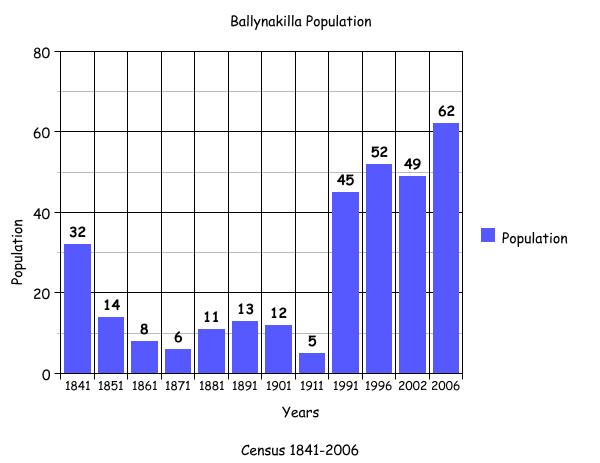
Census 1991 – 2006
The bar graph attached to this article plots the changes in population in this townland between 1841 and 2006 according to census information[14].
Mapping Change
The Ordnance Survey (OS) Map (1837-1842)[15] shows a road dissecting the townland in the south with 2 buildings visible near the border with Pollbaun. A comparison between the 25 Inch Map 1888-1913[16] and the 2005 Aerial Map[17] shows how the landscape and geography of the area have changed. The 1888-1913 Map shows a sheepfold in the centre of Ballynakilla while the southern portion of the townland seems to have been boggy or marshy ground. This area was bordered in the south by the Grange river that flowed along the border of the neighbouring townlands of Cahergal and Barbersfort. The area to the south of the river into Cloonlusk was liable to flooding and this would have contributed to the marshy ground in the south of the townland.
The modern day OS 2000 and 2005 Maps show a large quantity of houses along the road leading from Barbersfort into Ballynakilla, which is reflected in the modern census figures. In 2006 there were 16 families listed living in this townland. No houses have been constructed in the centre of the townland and this area continues to be green fields used for hay and other farming purposes. The route of the Grange river has changed somewhat over the years. A small ox-bow type area did exist in the south of the townland where the river water flowed around a loop of land eroding a path and creating a small, island-type area of land before rejoining the river again[18]. This is no longer visible and the river flow has shifted slightly to the south before continuing its traditional route into Barbersfort in the southeast.
[1] Logainm.ie, ‘Placenames Database of Ireland’, (http://www.logainm.ie/Viewer.aspx?text=Ballynakilla&streets=yes) (May 2011).
[2] Killererin Magazine Committee ‘Parish of Killererin’ in Out and About in Killererin (2006) p.110
[3] Trinity College, Dublin, ‘The Down Survey’ (http://downsurvey.tcd.ie/landowners.php#mc=53.519656,-8.805316&z=14) (22 May 2013)
[4] Galway County Library,‘O’Donovan’s Field Name Books’(http://places.galwaylibrary.ie/asp/fullresult.asp?id=26055) (May 2011)
[5] Galway County Library,’O’Donovan’s Field Name Books’(http://places.galwaylibrary.ie/asp/fullresult.asp?id=26055) (Apr 2011)
[6] PODUNK ‘Place Types and Land Allocation in Ireland’ (http://ei.epodunk.com/place-types.html) (June 2011) An Irish acre, the measure used from the 17th century, equalled 1.62 statute (English) acres, also called a plantation acre
[7] Galway County Library,’ O’Donovan’s Field Name Books’(http://places.galwaylibrary.ie/asp/fullresult.asp?id=26055) (May 2011)
[8] ‘Table VII –Area, Out-offices and Farm Steadings and Population together with the Valuation of Each Parish, Townland and Township of the County of Galway in 1881’ (James Hardiman Library, National University of Ireland, Galway, p38)
[9] Ask about Ireland, ‘Griffith’s Valuation’ (http://www.askaboutireland.ie/griffith-valuation/index) (May 2011)
[10] ‘Table VII –Area, Out-offices and Farm Steadings and Population together with the Valuation of Each Parish, Townland and Township of the County of Galway in 1881’ (James Hardiman Library, National University of Ireland, Galway, p21)
[11] Census of Ireland for the Year 1911 [Province of Connaught, County of Galway] Area, Houses and Population, ‘Table VII-Area Houses Out-Buildings and Farm Steadings, and Population together with the Valuation of Each Poor Law Union, Dispensary District, Electoral Division, Townland in the County of Galway in 1911’ (Galway County Library, p110)
[12] The National Archives of Ireland, ‘Census of Ireland 1901/1911’ (http://www.census.nationalarchives.ie/pages/1901/Galway/Killererin/Ballynakilla/1401074/) (May 2011)
[13] The National Archives of Ireland, ‘Census of Ireland 1901/1911’ (http://www.census.nationalarchives.ie/pages/1911/Galway/Killererin/Ballynakilla/547896/) (May 2011)
[14] Kids Zone Learning with NECS ‘Create a Graph’, (http://nces.ed.gov/nceskids/createagraph/default.aspx?ID=6a334b2bea6040ee8a7a6a409af127d8) (Feb 2012)
[15] Ordnance Survey Ireland, ‘25” Historical Map 1888-1913’ (www.osi.ie/publicviewer) (May 2011)
[16] ibid
[17] ibid
[18] Geography at About.com, ‘Oxbow Lakes’ (http://geography.about.com/library/weekly/aa010601a.htm) (Feb 2012)
No Comments
Add a comment about this page