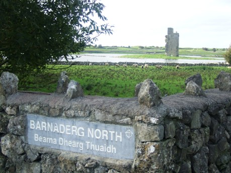
Barnaderg North


Location and origin
The townland of Barnaderg North is situated in the Civil Parish of Killererin in the Barony of Clare. The townland is bordered on the north by Pollacappul, the south by Carrowmannagh, the east by the townlands of Knock, Cottage and Barnaderg South and the West by Garraun. The Down Survey, a mapping survey carried out between 1656 and 1658 planned to more accurately map the townlands of Ireland. This Survey records the townland as ‘Danngennagher’, Parish of ‘Killereran’[3]. In Barnaderg North in 1641 the owners were listed as ‘Hugh O’Kelly (Catholic)’ and in 1670, Patrick Lynch (Catholic) and ‘Dominick Skerritt (Protestant)’. There is no detail in relation to any forfeited land.
According to O’Donovan’s Place Name Books 1830[4] early references to ‘Barnydarg’ were found in the Chancery Inquisitions of Elizabeth I (1558-1603), to ‘Barnadregge’ and ‘Bearnydarg’ in the Chancery Inquisitions of James I (1603-1625), to ‘Bearnederg’ in the Chancery Inquisition of Charles I (1625-1649) and to ‘Barnedarge’ in the Chancery Inquisition of William III (1689-1702). Today, locally, the townland is spelt ‘Barnaderg North’.
Townland ownership
The townland was described as the property of H.R. Henry, Esquire of England and contained ‘307½ acres statute measure[5], all arable land’[6]. Henry also held land in other townlands in the parish of Killererin including Addergoole, Ballynakilla, Carrowgorm, Cloonconra, Cloonriddia, Cooldorragha, Coolrevagh, Cornacartan, Corralea, Corskeaghbeg, Creevaghbane, Grange, Kilmore, Killeighter, Lisnaminaun, Lisavalley, Lisavalley Glebe, Omanbeg, Omaunmore, Pollacapple, Pollaun, Shantallow, Tigreenaun, Togherbeg and Toghermore.
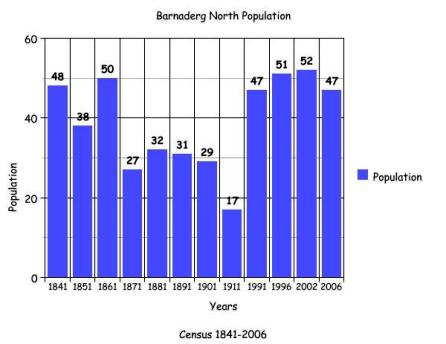
Census 1841-1851[7]
There were 48 people living in 8 houses in Barnaderg North in 1841 and this figure decreased by 1851 to 38 people in 7 houses. The total acreage of the townland in 1841 was 308 acres, 1 rood and 3 perches while the annual valuation was £136 0s 0d.
Griffith’s Valuation 1855[8]
There were 5 occupiers of land listed on Griffith’s Valuation in 1855. Philip Ormsby leased a herds house, office and lands from Hugh Henry in the amount of 220 acres, 1 rood and 8 perches at an annual valuation of £125 10s 0d. Patrick Commons also leased land from Henry that included two plots, the 1st measuring 51 acres, 0 roods and 11 perches and the 2nd measuring 26 acres, 3 roods and 24 perches. Both of these plots incorporated a house and offices as well as land. Patrick Commons in turn sub-let an area of land to Timothy Tierney measuring 3 acres, 2 roods and 26 perches. Loughlin Ryan and Michael Dooley also leased a plot including a house and land from Ormsby measuring 6 acres, 1 rood 20 perches. The total annual valuation of the land in the townland was £174 0s 0d.
Census 1861-1881[9]
There were 50 people living in 7 houses in the townland in 1861 and this population almost halved to 27 people living in 4 houses in 1871. This increased slightly in 1881 to 32 people living in 5 houses. The total acreage of the townland in 1881 was 308 acres, 1 rood and 8 perches with an annual valuation of £176 0s 0d.
Census 1891[10]
There were 31 people living in 3 houses in Barnaderg North in 1891.
Census 1901[11]
There were 29 people living in 3 houses in the 1901 Census for Barnaderg North. There were 2 large families recorded in the townland; the 1st was the Nolan family and the 2nd was the Mannion family.
Nolan family
Patrick Nolan, aged 60 was a farmer and married to Julia, aged 50. Their 9 children lived with them and were all recorded as scholars and farmer’s children; James, aged 23, Norah, aged 21, Mary, aged 19, Michael, aged 17, Maggie, aged 15, John and Peter, aged 13 , Patrick, aged 8 and Julia, aged 7.
Mannion/Donlon
John Mannion, aged 40 and a farmer was married to Anne, aged 35. The family included 4 sons; Thomas, aged 19, James, aged 16, Walter, aged 13, William, aged 12 and 4 daughters; Maggie, aged 23, Mary, aged 14, Anne, aged 8 and Norah, aged 7 years. Their eldest daughter Maggie was married and had a son, John Donlon, aged 1 year. John was born in America.
Ronan family
The 3rd family in the townland was the Ronan family. James Ronan was a shepherd, aged 60 who was married to Margaret, aged 55. This family also included 2 sons; William, aged 19 and Denis, aged 17 years, and a daughter Kate, aged 15. There were also 2 grand-children listed in this house; James, aged 11 and Martin, aged 6. There is no detail given in relation to the parents of James and Martin, though it is possible they were living and working elsewhere, probably America where the children were born.
Occupations
Both the Mannion and Nolan families were farmers while the Ronan family were listed as shepherds. Many of the children were listed as scholars. The older children helped their fathers on the land and were listed as either ‘farmer’s son’ or ‘shepherd’s son’. All of the occupants of the townland listed their place of birth as ‘Co. Galway’ with the exception of James and Martin Ronan and John Donlon who were born in America.
Types of property
Patrick Nolan held the only 1st class house in the townland. The home had a roof of slate and had 8 windows in the front. Both John Mannion and James Ronan had 2nd class houses with roofs of thatch and 3 front windows in each house. Patrick Nolan and John Mannion owned the land on which their houses stood while Cecil R. Henry was listed as the landholder on which James Ronan’s house stood.
Oldest and youngest person in the townland
The youngest person in the townland in 1901 was John Donlon, aged 1 and the oldest people were Patrick Nolan and James Roan who were both aged 60 in 1901.
Census 1911[12]
The Mannion, Nolan and Ronan families are again listed in 1911 and are the only 3 families living in Barnaderg South during that time. John Mannion was aged 67 in 1911 and the family included his wife Anne and children Thomas, Walter, John, Annie and Norah. Maggie Donlon, aged 5, a grandchild also lived in this house. John and Anne were married for 36 years and had 10 children and 10 still living in 1911.
Ronan/Hanly
William Ronan was married to Kate and they had twin boys, Michael Bernard and James John, aged 7 months. In the Nolan house, Julia Nolan was listed as a widow in 1911. This home also included her children Michael, aged 29, Peter, aged 23 and daughter-in-law Kate, aged 28. Julia’s son was married 2 years and had no children. A boarder named as Norah Hanly also resided in this house. Norah was a scholar, aged 11. All of the families listed their occupation as ‘farmer’, including the Ronan Family who were listed as shepherds in 1901. Everyone recorded their place of birth as Co. Galway.
Types of property
There were 4 buildings listed on the House and Building Return in 1911 including an uninhabited private dwelling. As in 1901 the Nolan house was the only 1st class home listed, with 9 front windows. John Mannion held a 2nd class home with 4 front windows while William Ronan lived in a 3rd class house with 2 front windows. Only Nolan’s house had a slate roof.
There were 19 out-buildings listed in the 1911 Census, the majority held by the Nolan family, including a stable, coach-house, cow-house, calf-house, piggery, fowl-house, barn, potato-house and shed. The Ronan and Mannion families had 5 out-buildings including a stable, cow-house, piggery, barn and shed.
Oldest and youngest person in the townland
The youngest people in the townland in 1911 were the Ronan twins aged 7 months and the oldest was John Mannion, aged 67.
Census 1991-2006
The bar graph plots the changes in population in this townland between 1841 and 2006 according to census information[13].
Mapping Change
The Ordnance Survey (OS) Map (1837-1842)[14] shows Barnaderg Castle in ruins on the left hand side of the road leaving the village towards Tuam. Barnaderg Castle, a 16th Century Castle was the stronghold of the O’Kellys. According to the children of Barnaderg National School who studied the castle’s history, ‘Barnaderg Castle was built in medieval times by Malachy O’Kelly. He was married to Fionnuala O’Connor, daughter of Cathal Craobh Dearg O’Connor. They probably lived in a fort in the area. In 1677 all the lands of Barnaderg and Abbeyknockmoy were given to an Englishmen named Nicholas Browne – about 2000 acres altogether. Some of the stone from Barnaderg Castle was used to build his house at Moyne Park’[15]. In the west and north-west of the castle ring forts are shown. According to this map the townland was very sparsely populated.
A comparison between the 25 Inch Map 1888-1913[16] and the modern Aerial Map 2005[17] shows how the landscape and geography of the area have changed. The 1888-1913 Map shows 5 ring forts all situated in the central and western parts of the townland. A disused gravel pit was situated close to the northern-most ring fort. The majority of this area was uncultivated or marshy ground.
Barnaderg National School
The 2005 Aerial Map shows all of the houses in the townland were built along the main road to Tuam including the new national school. In June 2008, a new €1.5m extension was opened at Barnaderg National School, which had at that time 87 pupils. The extension included a new classroom, a general purpose room, a library, a learning support room, a resource room, a staff room and an office and store rooms[18]. Some of the ring forts mentioned earlier can still be seen on the modern photographic map. The central portion of the townland is shown to be covered thinly with Gorse.
Today Barnaderg National School is located in Barnaderg North close to the GAA field developed. The most noticeable point of the townland is Barnaderg Castle and the nearby ring fort. ‘Castleview’ is now used as an address in this townland because of the proximity of some houses to the Castle.
Descendants still live in the area
The Ronan family, listed in the 1901 Census have descendants still living in Barnaderg North today though the name has changed over the years though marriage to ‘Byrne’. The Mannion name is also still in existence in the area. What was known as Nolan’s is now known locally as Dolan’s and owned by the Costello family. The forge at Dolan’s is well known in the local history of the area and the ruins are still evident there today, though the house itself has been demolished.
[1] Placenames Database, (http://www.logainm.ie/Viewer.aspx?text=barnaderg&streets=yes) (June 2011)
[2] Galway County Library, ‘O’Donovan’s Place Name Books’ (http://places.galwaylibrary.ie/asp/fullresult.asp?id=26069) (June 2011)
[3] Trinity College, Dublin, ‘The Down Survey’ (http://downsurvey.tcd.ie/landowners.php#mc=53.519656,-8.805316&z=14) (22 May 2013)
[4] ibid
[5] PODUNK ‘Place Types and Land Allocation in Ireland’ (http://ei.epodunk.com/place-types.html) (June 2011) An Irish acre, the measure used from the 17th century, equalled 1.62 statute (English) acres, also called a plantation acre
[6] Galway County Library, ‘O’Donovan’s Place Name Books’ (http://places.galwaylibrary.ie/asp/fullresult.asp?id=26069) (May 2011)
[7] ‘Table VII –Area, Out-offices and Farm Steadings and Population together with the Valuation of Each Parish, Townland and Township of the County of Galway in 1881’ (James Hardiman Library, National University of Ireland, Galway, p20)
[8] Ask about Ireland, ‘Griffith’s Valuation’ (http://www.askaboutireland.ie/griffith-valuation/index) (June 2011)
[9] ‘Table VII –Area, Out-offices and Farm Steadings and Population together with the Valuation of Each Parish, Townland and Township of the County of Galway in 1881’ (James Hardiman Library, National University of Ireland, Galway, p38)
[10] Census of Ireland for the Year 1911 [Province of Connaught, County of Galway] Area, Houses and Population, ‘Table VII-Area Houses Out-Buildings and Farm Steadings, and Population together with the Valuation of Each Poor Law Union, Dispensary District, Electoral Division, Townland in the County of Galway in 1911’ (Galway County Library, p110)
[11] National Archives Census of Ireland, ‘Census of 1901’ (http://www.census.nationalarchives.ie/search/results.jsp?census_year=1901&surname=&firstname=&county=Galway&townland=Barnaderg+North&ded=&age=&sex=&search=Search&relationToHead=&religion=&education=&occupation=&marriageStatus=&birthplace=&language=&deafdumb=&marriageYears=&childrenBorn=&childrenLiving=) (June 2011)
[12] National Archives of Ireland, ‘Census of 1911’ (http://www.census.nationalarchives.ie/search/results.jsp?census_year=1911&surname=&firstname=&county=Galway&townland=Barnaderg+North&ded=&age=&sex=&search=Search&relationToHead=&religion=&education=&occupation=&marriageStatus=&birthplace=&language=&deafdumb=&marriageYears=&childrenBorn=&childrenLiving=) (June 2012)
[13] Kids Zone Learning with NECS ‘Create a Graph’, (http://nces.ed.gov/nceskids/createagraph/default.aspx?ID=6a334b2bea6040ee8a7a6a409af127d8) (Feb 2012)
[14] Ordnance Survey Ireland, ‘25” Historical Map 1888-1913’ (www.osi.ie/publicviewer) (June 2011)
[15] Barnaderg National School ‘Local History’, (www.barnadergns.webs.com/history.htm) (June 2011)
[16] Ordnance Survey Ireland, ‘25” Historical Map 1888-1913’ (www.osi.ie/publicviewer) (June 2011)
[17] ibid
[18] Wikipedia -The Free Encyclopedia (http://en.wikipedia.org/wiki/Barnaderg) (June 2011)
No Comments
Add a comment about this page