Ballina, Baile an Fheadha, “woodtown[1]”


Location
The townland of Ballina is situated in the Civil Parish of Killererin. It is in the southwest extremity of the parish in the Barony of Clare and bordered on the north by the townland of Garra, on the west by Gortbeg and Brackloon and on the south and west by the townland of Ballyanapaurka also known as ‘Ballinapark’ and the parish of Abbeyknockmoy. The earliest reference to this townland is made in the Chancery Inquisitions of James 1 (1605-1625) as ‘Ballenea’. In the Boundary Sketch Map surveyed in 1813-1814 there is reference made to ‘Ballina[2]’
O’Donovan’s Field Name Books
According to O’Donovan’s Field Name Books 1830, early reference is made to this townland as “Baile an Átha and Baile an Fheadha.”[3] Authority source Mr. Gilmore; property tenant cites the townland as ‘Ballina’.[4] The townland is described as the property of Mr. John Skerritt, Ballinduff, who also owned lands in Gortbeg, Cloonlusk and Bracloon[5].
1841-1851 Census[6]
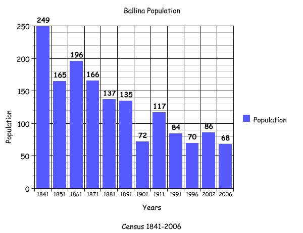
There were 45 households and 249 [111 males and 138 females] people living in Ballina in 1841. The population decreased to 165 [82 males and 83 females] in 1851 and the households decreased to 31. The big drop in population may have been the effect of the famine and people leaving the area and some having died.
Griffith’s Valuation 1855[7]
There were 29 landholders named in Griffith’s Valuation on a total of 738½ acres including 160 acres of bog and rough pasture and about 4 acres of plantation. All these tenants would have leased their land from Henry Blake and Martin J. Blake. Henry Blake retained a house, out-offices and cottiers’ houses, land and 251 acres, 2 roods and 37 perches of land for himself. Martin J. Blake held 150 acres, 1 rood and 27 perches of bog for himself. Thomas Gilmore was leasing land from the trustee’s of Dominick D. Skerrett. He held a herd’s house, out-offices and 56 acres 1 rood 19 perches of land of which he sub-leased 4 acres 1 rood and 23 perches to John Griffin. The tenants listed are Matthias Collins, Patrick Costello, Peter Shaughnessy, Peter Shaughnessy (a second P. Shaughnessy on a smaller amount of land), Michael and Francis Monaghan, Patrick Grealy, Patrick Niland, Hubert Hasty, Walter Hasty, Thomas Burke, Henry Blake, Martin J. Blake, Thomas Monaghan, James Hughes, Michael Griffin, Michael Hughes, Henry Hughes, Patrick Howley, Martin Howley, Patrick Howley Jun., Michael Grady, Andrew Mullin, Bridget Burke, Thomas Gilmore, John Gilmore, John Griffin.
1861-1881Census[8]
There were 34 houses and 196 people in the townland in 1861. In 1871, this had decreased to 31 houses and a population of 166. By 1881, there was a further decrease to 28 houses and a population of 137. As you will see from the graph below, the population had decreased by 112 between 1841 and 1881.
1891 Census [9]
There were 25 houses with a population of 135 in the townland in 1891.
1901 Census[10]
There were 11 houses and a population of 72 listed in the 1901 census. The heads of family included: Martin Joseph. Blake, James. J. Burke, Patrick Gilmore, Darby Langan, Michael McHugh, Honor Greally, Michael Gibbons, William Howley, Margaret Howley, Martin J. Curley and John Flaherty, all of whom lived in 2nd class houses. Bridget Hughes, Julia Gilmore, Thomas Costello, Martin Howley, Michael Burke, Martin Monaghan, Catherine Loughlin and Henry Cleveland all lived in 3rd class houses. Martin Josph. Blake aged 60, head of the family, (not married) and a farmer lived in a first class house.
James J. Burke
James J. Burke aged 57, head of the family, was married to Sarah aged 50 and they lived with their children Celia aged 28, Patrick aged 26, Delia aged 25, Mary A aged 22, Sarah L aged 20, John J. aged 19, Thomas aged 18, Norah aged 15, James aged 14, Michael F. aged 12, Julia aged 9, Martin J. aged 7 and James’s nephew Mark Connelly aged 11 also lived with them. They lived in a first class house.
Patrick Gilmore
Patrick Gilmore, aged 48, was married to Bridget aged 50 and they lived with their children Mariam aged 22, Jane aged 20, Thomas aged 12, Dominick aged 13.
Darby Langan
Darby Langan aged 45, was married to Bridget aged 40. They lived with their children Thos. aged 19, Michael aged 12, Patrick aged 10, John aged 2, Mary aged 20, Margret aged 17, Delia aged 14. James McDermott aged 75 was a servant and also lived in this house.
Michael McHugh
Michael McHugh, aged 66 was married to Kate aged 65. They lived with their son Michael aged 30 and daughter-in-law Honor aged 30 and grandchildren, Margaret aged 10, Kate aged 8, Denis aged 5, Delia aged 4, Maryanne aged 2 and Norah (infant).
Honor Greally
Honor Greally, head of the family, aged 62, (widow) lived with her children Margret Watters aged 35, (married) and another daughter is also listed as Margaret Greally aged 28 (spinster). Honor’s grandchildren Patrick Watters aged 4, Honor aged 1 and Ellen aged 1 also lived in this household.
Michael Gibbons
Michael Gibbons, head of the family, aged 70 was married to Catherine aged 65 and they lived with their daughter Ellen aged 25.
William Howley
William Howley, head of the family, aged 85, lived with his son Patrick aged 30 and his granddaughter Mary Hession aged 19 years.
Martin Howley
Martin Howley, head of the family, aged 89 lived with his son Patrick aged 40, daughter-in-law Julia aged 30 and grandchildren, Martin aged 3 and William aged 1.
Margaret Howley
Margaret Howley, head of the family aged 70, lived with her son Patrick aged 35, her daughter-in-law Ellen aged 25 and grandaughter Mary Ellen aged 4.
Martin J. Curley
Martin J. Curley head of the family, aged 35 years was married to Nora Curley aged 33. They lived with their children: Michael B aged 11, Mary Teresa aged 9, Mattie Joe aged 8, Patrick F aged 6, Richard Thos. aged 4, John Anthony (infant). Mary Reilly, a servant aged 18 and Catherine Geraty aged 60 (widow) also lived with them.
John Flaherty
John Flaherty head of the family, aged 29, was married to Anne aged 29. They lived with their son Michael aged 1. Sabina Shea aged 80 was listed as a visitor.
Bridget Hughes
Bridget Hughes, head of the family, aged 67 was a widow and lived with her son John aged 35 and daughter-in-law Mary aged 36. Her grandchildren Mary aged 8, Delia aged 6, Michael aged 5 and Ellen aged 3.
Julia Gilmore
Julia Gilmore, head of the family and a widow aged 50, lived with her children Dan aged 29, Catherine aged 25, Norah aged 17, Mich. Thos. aged 15 and her granddaughter Mary A. Glynn aged 12.
Thomas Costello
Thomas Costello, head of the family, aged 62 was married to Mary aged 60. They lived with their daughter Norah aged 28 and son-in-law Richard Holian aged 31. Mary Hughes aged 65, a cousin is also listed in this house.
Michael Burke
Michael Burke, head of the family, aged 66 was married to Margaret aged 50. They lived with their children James aged 19, Patrick aged 15, Thomas aged 12, Margaret aged 11, William aged 9, Kate aged 7 and Ellen aged 5.
Martin Monaghan
Martin Monaghan, head of the family, aged 65 was married to Catherine aged 71. They lived with their daughter Mary aged 30 and grandaughter Bridget Blake aged 13.
Catherine Loughlin
Catherine Loughlin, head of the family aged 50 and a widow, lived with her children Michael aged 22, John aged 20 Kate aged 15 and Ellen aged 13.
Henry Cleveland
Henry Cleveland, head of the family aged 31, was married to Bridget aged 30. They lived with their children Mary Bridget aged 13, Julia Ellen aged 4 and Anndie Elizabeth (infant).
Occupations
All householders list their occupation as ‘scholars’ or ‘farmers’ with the exception of Celia Burke and Martin J. Curley who were a national schoolteachers; Catherine Geraty who was a children’s nurse; James McDermott and Mary Reilly were listed as domestic servants; John Flaherty was a shepherd, Sabina Shea was a wool-spinner. Henry Cleveland was a rural postman. Born in England, he was a member of the Church of England. He was appointed firstly as a rural postman in December 1898 in the Ballyglunin to Killererin area and secondly in 1902 to the Ballyglunin to Barnaderg-Athenry area.[11]
1911 Census[12]
There were 18 houses listed in Ballina in the 1911 census and a population of 117. Garra School is also listed as being in the townland of Ballina at that time.
Blake household
The head of the Blake Household was John Joseph Blake aged 36 years and his occupation was as a farmer and a civil engineer. Also in the Blake household was his sister Mary Anne Blake aged 33 years and his mother Bridget Blake aged 59 years. Bernard Kilkelly, aged 23 worked as a farm servant for the Blake Household as did James Lally aged 52.
Heads of household 1911
Martin Curley was still the head of his household and by now his wife Norah was a national school teacher as was his daughter Mary Teresa aged 19. The households remained much the same with the heads of families being Patrick Gilmore, Martin Monaghan, Michael Burke, Margaret Howley, Patrick Howley, John Flaherty, John Hughes, Julia Gilmore, Thomas Kelly, John Hughes, Darby Langan, John Loughlin, Thomas Costello, Michael McHugh and James J. Burke.
1926-1990 Census
There is no statistical information in relation to this townland until 1991.
1991 Census[13]
There were 22 houses in Ballina in 1991 and a population of 84.
1996 Census[14]
There were 21 houses and 70 people in this townland in 1996.
2002 Census[15]
By 2002 there were 25 houses and 86 people living in this townland.
2006 Census [16]
At this time there were 25 houses and 68 people living in this townland. Looking back to the year 1841 with a population of 249 living in 45 houses a big change has occurred through the years.
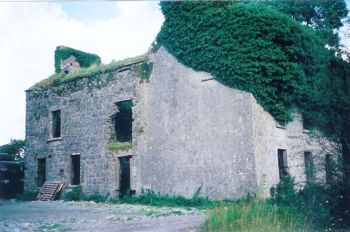
Ballina House[17]
The Ordnance Survey (OS) Maps (1837-1842) shows there was a Big House in this townland. This house is still standing today but is now in ruins. It was known as Ballina House and was built in 1833 by Henry Blake and was occupied by members of the Blake family. Ballina House gave employment to local men and women until 1952 when the Atheson family went to live in Ballyglunin House after his father John Blake died. Mrs Blake, John’s widow, died in 1953. The land was divided amongst the local farmers. Today only the ruins of the house remain with a plaque above the door inscribed by H.B. Esq.1833. In the 1950’s rates on property were high and roofs were stripped to avoid the payment. This happened all over Ireland, thus ruining a lot of old estates and homes[18].
Childrens’ Burial Ground
There is also a Childrens’ Burial Ground in Ballina not far from Ballina House. It can be clearly seen on the O.S map.[19] The village of Bóthar na Móinín was just beside the Ballyglunin Railway Station. It is thought that there was up to 100 families living there before the Famine. Even though meal was brought in during the famine, it is probable that the people either emigrated or died. There is no evidence of the village in the OS Maps. Bóthar na Móinín may have been Ballinapark and it was right beside the railway station which was a big village and is no more. This can be seen on OS Map 1837-1842.
Mapping Change
The Ordnance Survey Map (1837-1842)[20] shows Ballina as a large rectangular shaped townland. In the far north of Ballina, a road travelling from the northeast cuts into the townland branching in two. One road travels west into Gortbeg (along which a number of houses were located); the second branch travels south ending within the townland itself close to the border with Feigh West in the neighbouring parish. A number of lime kilns were located along these roads. In the west at the end of the road a ‘Pound’ was located close to the border of Garra and Gortbeg. Towards the centre of Ballina was a small, isolated wooded area where a number of buildings were located, which would have been Ballina House. To the south of the house a network of roads existed, leading into Gortbeg in the west and south into Ballynapark. A small number of houses were along the road and as in the north there were also a number of lime kilns. There were no houses in the east of Ballina. A comparison between the 25 inch map (1888-1913) and the modern aerial map (2005) shows how the geography and landscape of the area has changed and indeed how some areas have remained the same.
The 1888-1913 map shows the road network mentioned earlier and the dwellings situated along it. A road providing direct access to Ballina House and out-buildings was constructed by this time. an infants’ burial ground was situated close to the house, to the east. To the southwest of the house, some of the larger fields were sub-divided and there were a number of lime kilns and wells in the area. The area to the very south of Ballina was marshy and liable to flood, as was an area to the southeast. Today the same network of roads exists in the north of Ballina with some dwellings located along it as historically shown. Mature trees and hedges now surround many of these houses. Much of the townland is farm field and there is evidence of silage or hay cutting in some parts. Mature trees now surround the site of Ballina House.
There is no indication of the infant’s burial ground on the modern map. The area to the south liable to flooding is still boggy ground. There are no houses in this part of Ballina. The central part of the townland is uninhabited. All of the houses are situated along the road to the north close to the border with Garra and along the road on the western border with Gortbeg. Some houses have also been built on a side road off this, terminating close to Ballina House.[21]
Population graph
The graph accompanying this article shows the changes in population in this townland between 1841 and 2006 according to Census information.
[1] Placenames Database of Ireland (www.logainm.ie) (May 2011)
[2] Galway County Library, ‘O’Donovan’s Field Name Books’ (www.places.galwaylibrary.ie)(May 2011)
[3] ibid
[4] ibid
[5] ibid
[6]‘Table V11-Area, Out-Offices and Farm Steadings and Population together with the Valuation of Each
Parish, Townland and Township of the County of Galway in 1881’ (James Hardiman Library,
National University of Ireland, Galway, p38) (May 2011)
[7] Ask about Ireland, ‘Griffith’s Valuation’ (http://www.askaboutireland.ie/griffith-valuation/index) (May 2011)
[8]‘ Table V11-Area, Out-Offices and Farm Steadings and Population together with the Valuation of Each Parish, Townland and Township of the County of Galway in 1881’ (James Hardiman Library, National University of Ireland, Galway, p38) (May 2011)
[9] Census of Ireland for the Year 1911[Province of Connaught, County of Galway] Area, Houses and Population, ‘Table VII-Area Houses Outbuildings-Buildings and Farm Steadings, and Population together with the Valuation of Each Poor Law Union, Dispensary District, Electoral Division, Townland in the County of Galway in 1911’ (Galway County Library, p 99)
[10] The National Archives of Ireland, ‘Census Ireland 1901/1911’,
(http://www.census.nationalarchives.ie/search/) (May 2011)
[11] Ancestry.co.uk, ‘British Postal Service Appointment Book, 1737-1969’ (http:// search.ancestry.co.uk/cgi-bin/sse.dll?ti=5538&indiv=britipsapoint&h=218717) (April 2012)
[12] The National Archives of Ireland, ‘Census Ireland 1901/1911’,
(http://www.census.nationalarchives.ie/search/) (May 2011)
[13] Central Statistics Office, (www.cso.ie/census reports) (May 2011)
[14] ibid
[15] ibid
[16] ibid
[17] Ordnance Survey Ireland, ‘25” Historical Map 1988-1913’ (www.osi.ie/publicviewer) (May 2011)
[18] Local information and photographs supplied by Marie Regan, Ballina. (May 2011)
[19] Central Statistics Office, ‘Census Ireland 1901/1911’,
(www.cso.ie/census reports) (May 2011)
[20] Ordnance Survey Ireland, (www.osi.ie/publicviewer) (Jan 2012)
[21] ibid
No Comments
Add a comment about this page