Ballynapark, Baile na Páirce, “town of the park”[1]


Location
The townland of Ballynapark is situated in the Civil Parish of Killererin in the Barony of Clare. The townland is bordered on the north by Brackloon and Ballina, in the south by Coolfowerbeg, in the east by Culliagh North and in the west by the townlands of Bracklagh and Ardskea Beg. The Down Survey, a mapping survey carried out between 1656 and 1658, recorded the townland as ‘Knocknadrough’[2]. In Ballynapark in 1641, the owner was listed as ‘Richard Bourke (Catholic)’and in 1670 ‘Martin Kirwan (Protestant)’.
O’Donovan’s Field Name Books
According to O’Donovan’s Field Name Books 1830[3] early references to ‘Ballanapaurka’ were found in the Boundary Survey Sketch Maps completed during the field names survey (which began in 1824) officiated by John O’Donovan (1806-1861) and others[4]. Thomas Gilmore, recorded on that Survey as a proprietor’s tenant, and cited as an ‘authority source’, recorded the spelling of the townland as ‘Ballinapaurka’.
Property of M. Blake Esquire, Brooklodge
The townland is described as the property of M. Blake, Esquire, Brooklodge. It contains ‘273 acres statute[5] measure including about 140 acres of bog and rough ground’[6]. Blake owned large areas of land in the Parish of Killererin including plots in Brooklodge, Cloondahamper and Coolfowerbeg as well as lands in the Parish of Tuam and in Belclare. The total area owned by Blake in these townlands measured 2466 acres, 2 roods and 11 perches and had an annual valuation of £820 9s 9d.[7].
Census 1841-1851[8]
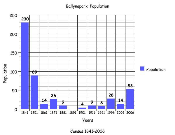
There were 233 people living in 45 houses in Ballynapark in 1841. By 1851 this population had greatly reduced to a figure of 89 people living in 20 houses. The total area of land in the townland in 1851 was 274 acres, 0 roods and 6 perches with a valuation of £49 0s 0d.
Griffith’s Valuation 1855[9]
There were 3 people listed on plots in the townland of Ballynapark in 1855. Dominick Donellan leased 3 plots; land from Martin J. Blake measuring 22 acres, 3 roods and 0 perches, land, a house and offices measuring 1 acre, 0 roods and 38 perches again from Blake and land measuring 4 acres, 0 roods and 12 perches from Mary Brady. Bridget Mullen leased land measuring 3 acres, 0 roods and 10 perches from Martin J. Blake, while Blake himself leased 2 plots, the first measuring 223 acres, 3 roods and 26 perches including a herd’s house, office and land from the Trustees of Dominick D. Skerritt and a second plot of plantation measuring 1 acre, 0 roods and 31 perches from Mary Brady.
Census 1861-1881[10]
There were 14 people living in Ballynapark in 1 house in 1861. By 1871 this had increased slightly to a population of 26 people living in 4 houses, and by 1881 the number had again decreased to 9 people living in 3 houses. The total area of land in the townland in 1881 was the same as 1851 measuring 274 acres, 0 roods and 6 perches with an annual valuation of £82 5s 0d.
Census 1891[11]
There were no people living in this townland in 1891.
Census 1901[12]
There was 1 family living in the townland in 1901. Head of Family, John Gibbons, aged 28 was married to Kate, aged 26 and they had 2 children; Mary Ellen, aged 3 and Andrew, aged 1. John Gibbons listed his occupation as ‘shepherd’. The Gibbons family lived in a 2nd class house with stone walls and a tiled roof. There were 5 windows in the front of this 3-roomed house, and it was located on land owned by Robert Blake. The oldest person in the townland was John Gibbons, aged 28 years and the youngest was Andrew Gibbons, aged 1 year old.
Census 1911[13]
There were 9 people living in Ballynapark in 1911 all from 1 family. Head of family John Gibbons was again listed, as well as his wife Catherine. In 1911 Catherine was aged 40 and John, aged 42. Along with Andrew and Mary Ellen mentioned in 1901 additional children were recorded; Catherine, aged 10, Delia, aged 8, Patrick, aged 6, John, aged 4 and Norah, aged 2.
As well as this 3-roomed house again listed as situated on the property of Robert Blake, a number of out-buildings were recorded including a cow-house, piggery and fowl-house. In 1911 Gibbons’ occupation was listed as ‘herd’. John Gibbons’ eldest son and daughter as well as the younger children were listed as scholars.
The oldest person in the townland in 1911 was John Gibbons, aged 42 and the youngest was Norah Gibbons, aged 2.
Census 1991-2006
The bar graph below plots the changes in population in this townland between 1841 and 2006 according to census information[14].
Mapping Change
The Ordnance Survey (OS) Map (1837-1842),[15] shows a road running along the north-west boundary with the neighbouring townland of Brackloon. A smaller road branched off here, bisected the north-eastern portion of the townland, leading to a number of buildings, approximately 40 in all. Short distances away to the north-east of these houses, 3 lime kilns were located. Another lime kiln was located not far from the border with Ballina, in the north-east and another in the south-west section of the townland near to the border with Coolfowerbeg.
A comparison between the 25 Inch Map 1888-1913 and the Aerial Map 2005,[16] shows how the landscape and geography of the area have changed. The 1888-1913 Map, shows a large area taking up the centre of the townland was liable to flooding. This area included the Athenry-Tuam Rail Line depicted on the 1888-1913 Map but not on the earlier 1837-1842 map. This railway line was situated in the north west of the townland and ran from Tuam Station through Ballyglunin in a south easterly direction. The entire track running through Ballynapark was at flood risk.
The OS modern-day Street Map shows that the road leading to the early dwellings has disappeared and between 2000 and 2005 a number of new houses have been built in the 1st field on the left entering Ballynapark from the townland of Ballina. In the south west 4 houses have also been built close to the railway line and there are approximately 17 dwellings visible. Outside of these inhabited areas much of the central and southern areas of the townland is green field with a small area in the south-east planted as forestry.
[1] Placenames Database of Ireland (http://www.logainm.ie/Viewer.aspx?text=ballynapark&streets=yes) (May 2011)
[2] Trinity College, Dublin, ‘The Down Survey’ (http://downsurvey.tcd.ie/landowners.php#mc=53.519656,-8.805316&z=14) (22 May 2013)
[3] Galway County Library, ‘O’Donovan’s Field Name Books’(http://places.galwaylibrary.ie/asp/fullresult.asp?id=26093) (May 2011)
[4] Galway County Library, ‘O’Donovan’s Field Name Books’(http://places.galwaylibrary.ie/asp/fullresult.asp?id=26038) (Apr 2011)
[5] PODUNK ‘Place Types and Land Allocation in Ireland’ (http://ei.epodunk.com/place-types.html) (June 2011) An Irish acre, the measure used from the 17th century, equalled 1.62 statute (English) acres, also called a plantation acre
[6] Galway County Library, ‘O’Donovan’s Field Name Books’(http://places.galwaylibrary.ie/asp/fullresult.asp?id=26093) (May 2011)
[7] ibid
[8] ‘Table VII –Area, Out-offices and Farm Steadings and Population together with the Valuation of Each Parish, Townland and Township of the County of Galway in 1881’ (James Hardiman Library, National University of Ireland, Galway, p38)
[9] Ask about Ireland, ‘Griffith’s Valuation’ (http://www.askaboutireland.ie/griffith-valuation/index) (May 2011)
[10] ‘Table VII –Area, Out-offices and Farm Steadings and Population together with the Valuation of Each Parish, Townland and Township of the County of Galway in 1881’ (James Hardiman Library, National University of Ireland, Galway, p38)
[11] Census of Ireland for the Year 1911 [Province of Connaught, County of Galway] Area, Houses and Population, ‘Table VII-Area Houses Out-Buildings and Farm Steadings, and Population together with the Valuation of Each Poor Law Union, Dispensary District, Electoral Division, Townland in the County of Galway in 1911’ (Galway County Library, p99)
[12] The National Archives of Ireland, ‘Census of Ireland 1901’ (http://www.census.nationalarchives.ie/search/results.jsp?census_year=1901&surname=&firstname=&county=Galway&townland=Ballynapark&ded=&age=&sex=&search=Search&relationToHead=&religion=&education=&occupation=&marriageStatus=&birthplace=&language=&deafdumb=&marriageYears=&childrenBorn=&childrenLiving= ) (May 2011)
[13] National Archives of Ireland ‘Census of 1911’ (http://www.census.nationalarchives.ie/search/results.jsp?census_year=1911&surname=&firstname=&county=Galway&townland=Ballynapark&ded=&age=&sex=&search=Search&relationToHead=&religion=&education=&occupation=&marriageStatus=&birthplace=&language=&deafdumb=&marriageYears=&childrenBorn=&childrenLiving=) (May 2011)
[14] Kids Zone Learning with NECS ‘Create a Graph’, (http://nces.ed.gov/nceskids/createagraph/default.aspx?ID=6a334b2bea6040ee8a7a6a409af127d8) (Feb 2012)
[15] Ordnance Survey Ireland, ‘25” Historical Map 1888-1913’ (www.osi.ie/publicviewer) (May 2011)
[16] ibid
No Comments
Add a comment about this page