Carrowgorm, An Cheathrú Ghorm "blue quarter" [2]


Location
The townland of Carrowgorm is situated in the Civil Parish of Killererin in the Barony of Tiaquin. The townland is bordered on the north by Garraun More, in the south by Feigh East, in the east by Carrowmanagh and in the west by Cahergal. According to O’Donovan’s Field Name Books 1830[3] the townland of ‘Carowgarme’ was referred to in the Chancery Inquisition of James I (1603-1625); the Map of Property 1813. It was also mentioned in the Boundary Survey Sketch Maps[4] and others, that cited the spelling of the townland as ‘Carrowgurm’. The 1841 Census refers to ‘Carrowgorn’[5]. Today locally, the townland is spelled ‘Carrowgorm’.
Property of H.R. Henry
The townland is described as the property of H.R. Henry, Esquire of England and contained 214¾ acres ‘statute[6] measure including about 10 acres of rough pasture’.[7] Henry also owned land in other parts of the parish including Addergoole, Ballynakilla, Barnaderg, Cloonconra, Cloonreddia, Cooldorragha, Coolrevagh, Cornacartan, Corralea, Corskeaghmore, Corskeaghbeg, Creevaghbaun, Grange, Killeighter, Kilmore, Lisnaminaun, Lissavalley and Lissavalley Glebe.
Census 1841-1851[8]
There were 40 people and 7 houses in Carrowgorm in 1841 and this population decreased to 22 people living in 6 houses in 1851. The total area of the townland was 214 acres, 3 roods and 22 perches with an annual valuation of £70 0s 0d.
Griffith’s Valuation 1855[9]
By the time of valuation of 1855 the number of occupiers was reduced to 5 people. Patrick Hanly leased 3 plots including 2 plots from Michael J. Browne measuring 19 acres, 3 roods and 12 perches and 7 acres, 0 roods and 30 perches as well as 1 plot from Hugh Henry measuring 78 acres, 3 roods and 23 perches. This large plot had an annual valuation of £28 0s 0d. Browne’s estate was offered for sale in 1855 in the Encumbered Estates Court and in 1857 Moyne House was bought by John Strafford[10].
Other occupiers included the Reverend John Kavanagh who leased a house, offices and land measuring 47 acres, 1 rood and 32 perches from Hugh Henry; William Murphy leased land measuring 38 acres, 3 roods and 35 perches from Henry; James Murphy leased land measuring 29 acres, 1 rood and 12 perches from Henry while John Gibbons leased a house and land measuring 2 acres, 1 rood and 8 perches from Patrick Hanly. The total valuation of the land in Carrowgorm in 1855 was £82 0s 0d. The Henry family owned Toghermore House, purchased from the bankrupt Deane family in 1790.
Census 1861-1881[11]
There were 18 people living in 3 houses in the townland in 1861 and this number decreased to 14 people living in 2 houses in 1871 and 16 people living in 2 houses in 1881. There were 13 out-buildings listed in the 1881 census with no uninhabited buildings. The total area of the townland measured 214 acres, 3 roods and 22 perches with an annual valuation of £76 0s 0d.
Census 1891[12]
There were 19 people living in 2 houses in Carrowgorm in 1891.
Census 1901[13]
There was 1 family of 7 people living in Carrowgorm in 1901. The head of family Martin Hughes aged 41 was married to Margaret aged 37. Martin and Margaret had 2 sons: John Thomas aged 2 and Martin Joe aged 1. The family lived with 3 servants Mary Walsh aged 19, Martin Lane aged 67 and John Mullowney aged 32.
All of those recorded listed their place of birth as Co. Galway. Martin Hughes was a farmer while Martin Lane and John Mullowney were farm servants. Mary Walsh was a domestic servant. The land on which the Hughes’ house was situated was owned by Martin Hughes and it was a 2nd class house made from stone with a slate roof and 3 front windows. In the 1901 census, 7 people occupied 5 rooms in what would have been a sizeable house.
The youngest person in the townland in 1901 was Martin Joe Hughes aged 1 and the oldest was Martin Lane aged 67.
Census 1911[14]
By 1911, there were 5 families living in the townland:
Thomas Gatley aged 60 was married to Ellen aged 45.
Michael Mullen aged 38 was married to Sarah, aged 29 and they had 1 daughter, Bridget aged 1. Michael Mullen also employed a servant, Thomas Raftery aged 32.
Michael Farrell aged 46 was married to Anne aged 45 and they lived with their children: Ellen aged 15, Delia aged 13, Michael aged 9, Patrick aged 5 and Mary Anne aged 4.
Patrick Moran aged 67 was married to Margaret aged 45 and they lived with their children: Michael aged 20, Mary aged 18, Brigid aged 17, Bina aged 15 and John aged 13. Patrick Moran also employed a servant, Michael Ryan aged 28.
Kate McKeigney aged 45 was married, though her husband was not named. Kate was a coachman’s wife and lived with her children: John Albert aged 21, Alfred Edward aged 16, William Herbert aged 16 and Eva Violet aged 11. A Robert McKegney is listed as a ‘coachman’ in Toghermore in 1911, probably Kate’s husband.
All those listed recorded their place of birth as Galway with the exception of Margaret Moran, Co. Mayo; William Herbert McKeigney, Dublin City; John Albert McKeigney, Co. Kildare; Alfred Edward McKeigney, Co. Kilkenny and Kate McKeigney, Co. Cork. Outside of that of farming, a number of occupations were listed including; Thomas Gatley who was a ‘carpenter’; Michael Mullen who was a ‘herd’; John Albert McKeigney who was a ‘chaffers’/domestic servant and Kate McKeigney who was a ‘coachman’s wife’.
All those recorded in this townland were Roman Catholics with the exception of the McKeigney family who were Church of Ireland or ‘Irish Church’. This McKeigney family were the only family of that name in Ireland recorded in the 1911 census who were members of the Church of Ireland. The other McKeigney families recorded in 1911 stated their place of birth as Co. Antrim, Co. Tyrone, Co. Cork and Co. Monaghan and all were listed as Roman Catholic.
A number of people in the townland were married for over 20 years including Margaret Moran who was married for 21 years and had 5 children with 5 still living in 1911; Ellen Gatley who was married for 25 years with no record of any children and Kate McKeigney who was married for 24 years and had 6 children born with 5 still living in 1911.
All of the land on which the houses in the townland were situated was owned by Patrick Moran with the exception of the Farrell and McKeigney land where it was owned by Cecil R. Henry. The Moran family lived in a 2nd class house with 1 front window. The house was made of stone with a roof of thatch. In this house 8 people lived in 5 rooms. This home also listed a number of out-buildings including a stable, coach-house, cowhouse, calf-house, dairy, piggery, fowl-house, barn and shed. The Farrell, McKeigney and Mullen families also lived in a 2nd class house while the Gatley family lived in a 3rd class house with 2 rooms.
Youngest and Oldest persons in the town in 1911
The youngest person in the townland in 1911 was Bridget Mullen aged 1 year and the oldest was Patrick Moran, aged 67.
Census 1991-2006
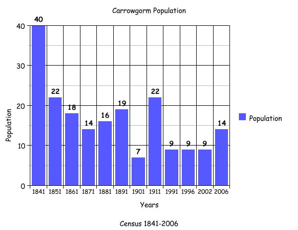
The bar graph seen here plots the changes in population in this townland between 1841 and 2006 according to census information[15].
Mapping Change
The Ordnance Survey (OS) Maps 1837-1842[16] show 2 forts in the centre of the townland. A road ran through Carrowgorm dividing it almost in equal halves and travelling from the direction of the Church in Carrowmannagh towards the townland of Clogherboy. Some dwellings were shown along this road while the majority were located in the north east of the townland close to the border with Garraunmore.
A comparison between the 25 inch Map 1888-1913 and the Aerial map 2005, shows how the landscape and geography of the area have largely remained the same.[17] The 1888-1913 map shows the forts in the centre of the townland as shown on the earlier map. Much of the townland’s centre was uninhabited and covered with a gorse type covering. The 2005 Aerial Photograph shows that the townland is entirely green field with evidence of dwellings and buildings along the townland’s borders but not at its centre.
[1] Placenames Database of Ireland (http://www.logainm.ie/)
[2] The Placenames database does not provide a placename meaning. The meaning provided comes from Galway County Library, ‘O’Donovan’s Field Name Books’ (http://places.galwaylibrary.ie/)
[3] Galway County Library, ‘O’Donovan’s Field Name Books’(http://places.galwaylibrary.ie/)
[4] ibid
[5] ibid
[6] PODUNK ‘Place Types and Land Allocation in Ireland’ (http://ei.epodunk.com/place-types.html) (June 2011) An Irish acre, the measure used from the 17th century, equalled 1.62 statute (English) acres, also called a plantation acre
[7] Galway County Library, ‘O’Donovan’s Field Name Books’(http://places.galwaylibrary.ie/)
[8] ‘Table VII –Area, Out-offices and Farm Steadings and Population together with the Valuation of Each Parish, Townland and Township of the County of Galway in 1881’ (James Hardiman Library, National University of Ireland, Galway, p77)
[9] Ask about Ireland, ‘Griffith’s Valuation’ (http://www.askaboutireland.ie/griffith-valuation/index) (Sep 2011)
[10] Landed Estates Database, ‘Browne Moyne’ (http://www.landedestates.ie/LandedEstates/jsp/family-show.jsp?id=1095) (Feb 2012)
[11] ‘Table VII –Area, Out-offices and Farm Steadings and Population together with the Valuation of Each Parish, Townland and Township of the County of Galway in 1881’ (James Hardiman Library, National University of Ireland, Galway, p108)
[12] Census of Ireland for the Year 1911 [Province of Connaught, County of Galway] Area, Houses and Population, ‘Table VII-Area Houses Out-Buildings and Farm Steadings, and Population together with the Valuation of Each Poor Law Union, Dispensary District, Electoral Division, Townland in the County of Galway in 1911’ (Galway County Library, p111)
[13] The National Archives of Ireland, ‘Census of Ireland 1901/1911’ (http://www.census.nationalarchives.ie/)
[14] National Archives of Ireland, ‘Census of 1911’ (http://www.census.nationalarchives.ie/)
[15] Kids Zone Learning with NECS ‘Create a Graph’, (http://nces.ed.gov/nceskids/createagraph/)
[16] Ordnance Survey Ireland, ‘25” Historical Map 1888-1913’ (www.osi.ie/publicviewer) (Sep 2011)
[17] ibid
No Comments
Add a comment about this page