Coolfowerbeg, Cúl Feabhair, “hill of the well (little)[1]


Location
The townland of Coolfowerbeg is located in the northwest extremity of the parish of Killererin, in the Barony of Clare. Ballynapark borders the townland on the north and Brooklodge Demesne borders it on the west and on the south and east by the parish of Abbeyknockmoy and also the south boundary is the river Abbert River running under Pallas Bridge. There is a ringfort in this townland bordering on Brooklodge Demesne. There is also a Childrens’ Burial Ground on the Coolfowerbeg side of Brooklodge.
O’Donovan’s Place Name Books
According to O’Donovan’s Place Name Books early references to ‘Culfower’ are found in the Chancery Inquisitions of James 1 (1603-1625)[2]. Coolfowerbeg is also referred to in the Boundary Survey Sketch Maps completed during the field names survey (which began in 1824) and others. The Survey also cited an authority source on the spelling of the townland ‘Coolfowerbeg’ supplied by Thomas Gilmore, Proprietors Tenant. The townland is described as the property of M. Blake, Esq., Brooklodge, a member of the Blake Family Ballyglunin, containing 113 acres, 2 roods 30 perches including 55 acres of bog with an annual valuation of £35 0s 0d.[3]
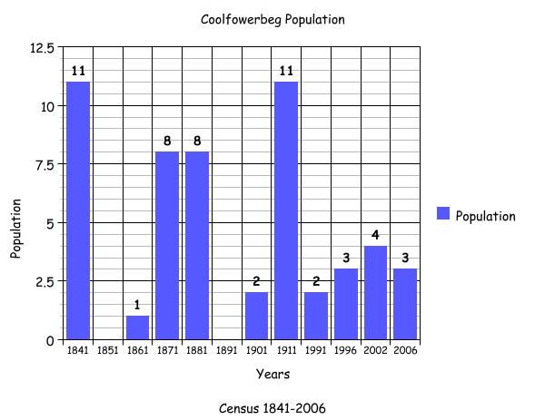
1841-1855 Census[4]
There was 1 household and 11 people living in Coolfowerbeg in 1841. By 1851 there were no people or houses in this townland.
Griffith’s Valuation 1855[5]
The only occupier of Coolfowerbeg townland is listed in Griffith’s Valuation 1855 as Martin J. Blake and he leased the land from the trustee listed, as Dominick Skerrett. The total area of land remained the same, 113 acres, 2 roods and 30 perches with a reduced annual valuation of £35 0s 0d.
By the time of Griffith’s Valuation Brooklodge was Skerrett property, but was held by the Blakes of Ballyglunin on a lease dated 1775.[6]
1861 – 1881 Census[7]
There was 1 person living in 1 house in the townland of Coolfowerbeg in 1861. In 1871 there was still 1 house with an increase in population to 8. By 1881 the number of households remained the same, as did the population. The area of land remained the same but the annual valuation increased to £74 5s 0d. which was a large increase.
1891 Census[8]
There was 1 house with no residents living in the townland in 1891.
Census 1901[9]
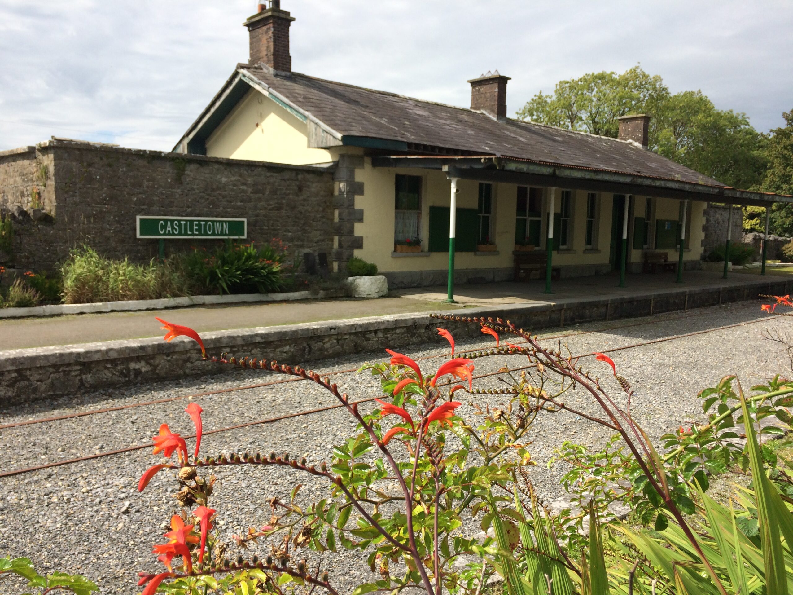
In the 1901 census the only building listed in the townland of Coolfowerbeg (District Electoral Division of Ballynapark) was a Railway Station, leased to Thomas Ahearn from the Railway Station Co. This building had a slate roof and it had 6 rooms with 5 windows to the front. It was a 2nd class building. The head of the household was Thomas Ahearn aged 52 years, occupation Railway Station Master. He was married to Ellen aged 45 years and they both came from Co. Tipperary.
Census 1911[10]
There was 1 family living in the townland in 1911. The property was leased from Robert Blake. It was listed as a private building and it had 3 out-buildings, a turf shed a fowl house and a store.
This was probably the same building listed in 1901 as a railway station. The head of the household was William Gaffney aged 47 years and came from Queens County with an occupation listed as a Railway Station Master. He was married to Mary aged 37 years. They had 9 children, Patrick aged 16 years, Mary Ellen aged 15 years, Bessie aged 11 years, John aged 9 years, all born in Co. Kerry. Bridget aged 8 years was born in Co. Clare. Joseph aged 5, Michael aged 4 years, Kathleen aged 3 years and Nora aged 1 year were all born in Co. Galway. They had a total of 11 children born alive and 10 are listed to have survived.
Census 1991 – 2006[11]
Between 1991 and 2006 there was just 1 house listed in the census for this townland with a population of 2 and in 1991 and in 1996 there was a population of 3 with an increase to 4 in 2002 and it decreased to 3 in 2006.
Mapping Change[12]
According to the 1888-1913 OS map the railway station known, as Ballyglunin Station is the railway station referred to above as it was in the townland of Coolfowerbeg. The OS Maps (1837-1842) show Coolfowerbeg as a rectangular shaped townland with the Abbert River flowing along its southern border. There were no houses or buildings in evidence at this time. In the south-west of Coolfowerbeg, Pallas Bridge was located spanning the river between Coolfowerbeg and Brooklodge.[13]
A comparison between the 1888-1913 map and the modern photographic map 2005, shows how the landscape and geography of the area has changed and indeed what aspects have remained the same. By the time of the 1888-1913 Aerial Map[14] the Athenry-Tuam Railway line has been constructed along with Ballyglunin Station. A ‘goods-store’ was also located just south of the station across the railway track from a cattle pen. An infants’ burial ground was situated between a fork in two roads bordering Coolfowerbeg and Brooklodge. A very large area just north of Coolfowerbeg in the townland of Ballinapark was liable to flooding, an area that included the railway line itself. The 2005 aerial map shows that the townland is mostly green field with a forested area in the north east. Close to the railway track leading towards Tuam a building is situated and further west along the border with Brooklodge two further houses are located, one close to a fork in the road and another new building constructed between 2000-2005.[15]
The attached graph shows the changes in population in this townland between 1841 and 2006 according to Census information.
[1]Placenames Database of Ireland (www.logainm.ie) (Sep 2011)
[2] Galway County Library, ‘O’Donovan Place Name Books’ (www.places.galwaylibrary.ie) (Sep 2011)
[3]ibid
[4] ‘Table VII-Area, Out-offices and Farm Steadings and Population together with the Valuation of Each Parish, Townland and Township of the County of Galway in 1881’ (James Hardiman Library, National University of Ireland, Galway, p38) (Jan 2012
[5] Ask about Ireland, ‘Griffith’s Valuation’ (http://www.askaboutireland.ie/griffith-valuation/index
[6] National University of Ireland, ‘Landed Estates Database’ (http: landedestates.nuigalway.ie)(Feb 2012)
[7] ‘Table VII-Area, Out-offices and Farm Steadings and Population together with the Valuation of Each Parish, Townland and Township of the County of Galway in 1881’ (James Hardiman Library, National University of Ireland, Galway p38) (Jan 2012)
[8]Census of Ireland for the Year 1911[Provence of Connaught, County of Galway] Area, Houses and Population, ‘Table VII-Area Houses Outbuildings-Buildings and Farm Steadings, and Population together with the Valuation of Each Poor Law Union, Dispensary District, Electoral Division, Townland in the County of Galway in 1911’ (Galway County Library, p 99)
[9]The National Archives of Ireland, ‘Census Ireland 1901/1911’,
(http://www.census.nationalarchives.ie/search) (Jan 2012)
[10] Ibid
[11]Central Statistics Office, (www.cso.ie/census/report) (Jan 2012)
[12] Ordnance Survey Ireland, (www.osi/publicviewer) (Jan 2012)
[13] ibid
[14] ibid
[15] ibid
No Comments
Add a comment about this page