Dangan Polladooey


Location and origin
The townland of Dangan Polladooey is situated in the Civil Parish of Killererin in the Barony of Tiaquin. The townland is bordered on the north and west by Dangan Eighter, on the south by Dangan Slievegorm and the east by the parish of Moylough. According to O’Donovan’s Field Name Books 1830, early references to ‘Pulladoey’ were found in the Boundary Survey Sketch Maps[2]. The survey also cited an ‘authority source’ on the spelling of the townland as ‘Pulladoey’ supplied by Pat McGann, bailiff[3]. Finally, the survey noted that there was an ancient fort in the western part of the townland. According to information from W. Joyce’s Place Names, ‘Poll’ or ‘Poul’ often referred to a hole in the ground, in a river or bog, or sometimes ‘an excavation or cavern’.[4]
Property of Lord Lorton
Polladooey was described as the property of Lord Lorton, Sligo. It contained ‘156½ acres statute[5] measure including about 17 acres of bog’.[6] Lord Lorton also owned land in Dangan Eighter, Dangan Oughter, Danganbeg and Dangan Slievegorm amounting to 1302 acres, 2 roods and 20 perches[7]. Lord Lorton was a member of the King Family which was one of the most influential landed families in the West of Ireland. They also held land in Co. Cork as the Earls of Kingston[8].
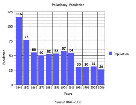
Census 1841-1851[9]
There were 116 people or 17 households in Polladooey in 1841 and this population more than halved in 1851 to 77 people and 13 households. The total area of the land in Polladooey was 156 acres, 0 roods and 22 perches with an annual valuation of £50 0s 0d.
Griffith’s Valuation 1855[10]
There were 12 occupiers of land in Polladooey in 1855 including Michael Fleming, George Gilligan, John Gannon, Patrick Gilligan, Patrick Joiner, Michael Corbett, Patrick Holian, James Kirwan, William Fahy, Patrick Joiner, Peter Gannon and Michael Bourke. The majority of the land was leased from Michael J. Browne with the exception of Michael Bourke and John Gannon. Between 1830 and 1855 the lands were previously owned by Lord Lorton.
The Kings (the family name of the Lords Lorton) were granted over 23,000 acres of land in Connacht[11] in the 1600s but by 1855 some of this land was owned by Michael J. Browne. Browne who owned Moyne House held large areas of land in Killererin and later in 1855 his estate was offered for sale under the Encumbered Estates Court. In 1857 Moyne house and over 1,000 acres of Browne’s estate was purchased by John Stratford Kirwan[12].
Michael Bourke leased an area including a house and land from Peter Gannon measuring 13 acres, 0 roods and 10 perches while John Gannon leased an area of ‘water’ measuring 6 acres, possibly a portion of Horseleap Lough[13]. John Gannon and Patrick Gilligan also leased a 2nd area of land each.
The largest areas of land were held by Michael Fleming who leased land from Browne measuring 26 acres, 2 roods and 38 perches. Patrick Joiner leased a house, offices and land measuring 33 acres, 2 roods and 33 perches and John Gannon leased a house, office and land measuring 13 acres, 0 roods and 10 perches.
John Gannon’s house and out-buildings (on just over 13 acres) had the largest rateable annual valuation at £3 0s 0d. The smallest plots of land were held by Michael Bourke who retained 1 acre, 1 rood and 10 perches and Patrick Holian who held a house and land measuring 1 acre, 2 roods and 13 perches.
Census 1861-1881[14]
There were 55 people or 9 households living in the townland in 1861. The population decreased slightly in 1871 to 50 people but still having 9 households and in 1881 the population increased to 52 people and 11 households. The total area of land in the townland in 1881 was 156 acres, 0 roods and 22 perches with an annual valuation of £67 2s 0d. In 1881 there were 22 out-buildings listed in Polladooey.
Census 1891[15]
There were 10 households and 53 people living in Polladooey in 1891.
Census 1901[16]
There were 11 heads of household or 57 people listed in Polladooey in 1901.
Gilligan family (1)
Daniel Gilligan, aged 30 was unmarried. Daniel lived with his sister Margaret aged 27 and his brother Edward, aged 23.
King family
Margaret King, aged 60 was a widow. Margaret lived with her children; Stephen aged 25, Michael, aged 24, Celia aged 23 and Kate aged 21.
Langan family
Patrick Langan aged 60 was a widower. Patrick lived with his children: Thomas aged 20, William aged 18, Mary aged 16, John aged 14, Julia aged 12, Margaret aged 10, Kate aged 8 and Norah, aged 5.
Connaughton family
Patrick Connaughton aged 45 was married to Elizabeth aged 45. Patrick and Elizabeth lived with their children: Patrick aged 20, Ellen aged 16, Maria aged 14 and Michael aged 10.
Gannon family (1)
Edward Gannon aged 42 was unmarried. Edward lived with his sister Hannah aged 27.
Connaughton family (2)
Patrick Connaughton aged 47 was married to Ellen aged 44. Patrick and Ellen lived with their children: Thomas aged 18, William aged 12 and Margaret aged 14.
Gilligan family (2)
Anne Gilligan aged 82 was a widow. Anne lived with her son Thomas aged 40, her daughter-in-law Bridget aged 37 and her grandchildren Patrick aged 2, Michael aged 1 and Bridget who was less than 1 year old.
Higgins/Gannon
John Higgins aged 40 was married to Ellen aged 30. John and Ellen lived with their children: Michael aged 9, James aged 7, Patrick aged 5, John aged 2 and Malachy who was less than 1 year old. John’s sister, Mary Higgins aged 45 also lived in the house as well as his nephew, Edward Gannon aged 21.
Holian family
Patrick Holian aged 82 was a widower. Patrick lived with his son James aged 40 and daughter-in-law Ellen aged 35.
Mannion/Donohoe
Thomas Mannion aged 50 was married to Margaret aged 43. Thomas’ niece Delia Donohoe aged 20 lived in this home also.
Fahey family
Bridget Fahey aged 82 was a widow. Bridget lived with her daughter Mary aged 48 who was also a widow. Mary’s children also lived in this house: William aged 22, Bridget aged 16, Thomas aged 13 and James aged 10.
Occupations
All of those recorded in 1901 listed their place of birth as ‘Co. Galway’ and all those of working age recorded their occupation as ‘farmer’ with the exception of Hannah Gannon, Margaret Gilligan and Mary Higgins who were ‘seamstresses’. Delia Donohoe was a ‘dressmaker’ and John Higgins was a ‘herd’.
Property ownership
All of those listed on the ‘House and Building Returns’ owned the land on which their houses were located with the exception of Anne Gilligan, where the land was owned by Thomas Gilligan and also Bridget Fahy, where the land was owned by Malachy Fahy. Most likely, these were the husbands’ names as they were listed as widows in the 1901 census. In the case of John Higgins, the land was owned by Robert W. Waithman. Robert Waithman, according to the Landed Estates Database, was a member of a Lancashire family, who came to Ireland during the 1860s and bought land and estates under the Landed Estates Court. As well as land in Galway City and Roscommon, he purchased Moyne Park and came to own over 3,000 acres in Co. Galway[17].
All of the houses listed on the 1901 census were 2nd class houses with the exception of Edward Gannon who lived in a 1st class house with 8 front windows. In this house 2 people occupied 6 rooms. In the houses of John Higgins and Patrick Langan, 9 people occupied 3 rooms. Many of the houses listed recorded out-buildings and all houses had a stable, cowhouse, piggery and fowl house. Others also had a calf-house while others still held a barn. There were a total of 53 out-buildings in the townland.
The youngest people in the townland in 1901 were Bridget Gilligan and Malachy Higgins who were less than 1 year old. The oldest people in the townland were Anne Gilligan, Bridget Fahey and Patrick Holian all of whom were aged 82 in 1901.
Census 1911[18]
There were 11 heads of household or 54 people listed on the 1911 census.
Langan family
Patrick Langan, aged 72 was a widower. Patrick lived with his children John aged 24, Julia aged 19, Maggie aged 17 and Nora aged 13.
Holian family
James Holian aged 58 was married to Ellen aged 50.
Mannion family
John Mannion aged 33 was married to Delia aged 31. John and Delia lived with their children; Thomas aged 6, Patrick aged 4, Mary aged 3 and Edward aged 1. John’s uncle Thomas aged 69 and his aunt Margaret aged 60 also lived with them.
Connaughton family (1)
Patrick Connaughton aged 55 was married to Ellen aged 56. They lived with their son Patrick aged 31.
Gannon family
Edward Gannon aged 68 was unmarried and lived alone.
Connaughton family (2)
Patrick Connaughton aged 63 was married to Eliza aged 64. They lived with their children Patrick aged 31 and Maria aged 26.
Higgins family
John Higgins aged 56 was married to Ellen aged 46. They lived with their children: Michael aged 19, James aged 17, John aged 12, Malachy aged 10, Mary Ellen aged 5 and Sarah aged 3.
Fahy family
Mary Fahy aged 68 was a widow. Mary lived with her sons Thomas aged 24 and William aged 32.
Gilligan family (1)
Thomas Gilligan aged 60 was married to Bridget aged 50. They lived with their children: Patrick aged 12, Michael aged 11, Bridget aged 9, Anne aged 7 and Margaret aged 5. Thomas’ brother-in-law Patrick aged 60, also lived in this house.
Gilligan family (2)
Daniel Gilligan aged 38 was married to Norah aged 31. Daniel and Norah lived with their children: Delia aged 8, Edward aged 7, Mary Anne aged 5, Ellen aged 3 and Margaret aged 2.
King family
Stephen King aged 36 was married to Mary aged 26. Stephen and Mary lived with their son Martin aged 3. Stephen’s brother, Michael aged 40 and his sister Kate aged 30 also lived in this house. These families are the same as those recorded in 1901.
Occupations
As in 1901 all those of working age recorded their occupation as ‘farmer’ while Michael King was listed as a ‘farm servant’ and John Higgins a ‘herd and farmer’. All occupants listed their place of birth as Co. Galway.
All occupants owned the land on which their houses were located with the exception of Daniel Gilligan, where the land was owned by Thomas Gilligan. In 1901, this same land was listed as belonging to Daniel. The majority of land occupiers held 5 to 6 out-buildings while Edward Gannon only held a fowl-house and cow-house. Most other occupants recorded at least a piggery, shed, fowl-house, cow-house and barn.
A number of people in the townland were married for 30 years or over including Ellen Connaughton who was married for 32 years and had 7 children with 5 still living in 1911; Margaret Mannion, married 33 years with no detail of any children born and Eliza Connaughton aged 64, married 34 years with 7 children born and 5 still alive in 1911. The youngest person in the townland in 1911 was Edward Mannion aged 1 and the oldest person was Patrick Langan aged 72.
Census 1991-2006
The bar graph below plots the changes in population in this townland between 1841 and 2006 according to census information[19].
Mapping changes
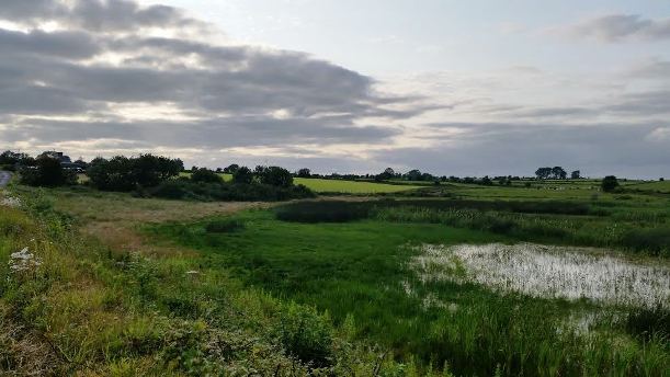
The Ordnance Survey (OS) Maps 1837-1842[20] show that the townland is triangular in shape with a portion of Horseleap Lake located in the south-east of the townland. The lake spreads in to the neighbouring townland of Lecarrow. The main inhabited portion of the townland was located in the southwest and was reached by a road from the northeast. At the head of this road, a lime kiln and a small number of buildings were located. The main inhabited area included houses each surrounded by small trees or shrubs in a possible Clachan-type settlement. To the west, a fort was located. To the south of the fort, on the border with Dangan Oughter, a Post Office was situated.
A comparison between the 25 inch map 1888-1913 and the Aerial map 2005[21] shows how the landscape and geography of the area has mostly remained the same. The 1888-1913 map, shows Horseleap crossroads and an area surrounding it, liable to flooding. On the 19th March 1890, the map recorded the ‘surface of water’ at the lake as 203.4 ft, presumably the size of the area. A gravel pit was also located close by the lake. At the Post Office, a Bench Mark reading was recorded of 296.8ft[22]. The fort was still recorded in the west of Polladooey on this map and a well and lime kiln were recorded in the northeast.
The 2005 Aerial map shows dwellings in the same area of the townland as on the early maps. The surrounding areas are made up of green fields used for farming purposes. In 2005 some of the fields in the northeast were cut for silage or hay. The lake previously located in the southeast near Horseleap crossroads, no longer extends as far into the townland, and indeed seems to have dried up somewhat though the outer edges are still clearly visible on the photographic map as an area liable to flood.
[1] Placenames Database of Ireland (http://www.logainm.ie/)
[2] Galway County Library, O’Donovan’s Field Name Books’(http://places.galwaylibrary.ie/)
[3] ibid
[4] ibid
[5] PODUNK ‘Place Types and Land Allocation in Ireland’ (http://ei.epodunk.com/place-types.html) (Aug 2011) An Irish acre, the measure used from the 17th century, equalled 1.62 statute (English) acres, also called a plantation acre
[6] Galway County Library, O’Donovan’s Field Name Books’(http://places.galwaylibrary.ie/asp/fullresult.asp?id=26366) (Aug 2011)
[7] ibid
[8] National University of Ireland, Galway ‘Landed Estates Database’ (http://landedestates.nuigalway.ie:8080/LandedEstates/jsp/family-show.jsp?id=346) (Aug 2011)
[9] ‘Table VII –Area, Out-offices and Farm Steadings and Population together with the Valuation of Each Parish, Townland and Township of the County of Galway in 1881’ (James Hardiman Library, National University of Ireland, Galway, p56)
[10] Ask about Ireland, ‘Griffith’s Valuation’ (http://www.askaboutireland.ie/griffith-valuation/index) (Aug 2011)
[11] National University of Ireland, Galway, ‘Landed Estates Database’ (http://landedestates.nuigalway.ie)
[12] ibid
[13] Located on the 1837-1842 OS Map in the south east of the townland
[14] ‘Table VII –Area, Out-offices and Farm Steadings and Population together with the Valuation of Each Parish, Townland and Township of the County of Galway in 1881’ (James Hardiman Library, National University of Ireland, Galway, p56)
[15] Census of Ireland for the Year 1911 [Province of Connaught, County of Galway] Area, Houses and Population, ‘Table VII-Area Houses Out-Buildings and Farm Steadings, and Population together with the Valuation of Each Poor Law Union, Dispensary District, Electoral Division, Townland in the County of Galway in 1911’ (Galway County Library, p110)
[16] The National Archives of Ireland, ‘Census Ireland 1901/1911’, (http://www.census.nationalarchives.ie/)
[17] National University of Ireland, Galway ‘Landed Estates Database’ (http://landedestates.nuigalway.ie:8080/LandedEstates/jsp/family-show.jsp?id=1014) (Aug 2011)
[18] The National Archives of Ireland, ‘Census Ireland 1901/1911’, (http://www.census.nationalarchives.ie/)
[19] Kids Zone Learning with NECS ‘Create a Graph’, (http://nces.ed.gov/nceskids/createagraph/)
[20] Ordnance Survey Ireland, ‘25” Historical Map 1888-1913’ (www.osi.ie/pub;icviewer) (Aug 2011)
[21] ibid
[22] Ordnance Survey of Northern Ireland, ‘Vertical Datum in Ireland’(www.osni.gov.uk) (Aug 2011)
This measurement meant that this point of the land was above ‘Poolbeg datum’, which in turn was related to average sea level. The first levelling of Ireland was carried out between 1839 and 1843. It was referred to as ‘datum’, ‘taken to be the level of low water of a spring tide observed at Poolbeg Lighthouse in Dublin Bay on 8th April 1837’
No Comments
Add a comment about this page