Dangan Slievegorm


Location and origin
The townland of Slievegorm is situated in the east of the Civil Parish of Killererin and in the Barony of Tiaquin. It is bordered on the west by Lissavalley Glebe, on the north by Polladooey, the south by Dangan Beg and the east by Brierfield. According to O’Donovan’s Field Names Books of 1830,[2] early references to ‘Slievegorm’ are made in The Boundary Survey Sketch maps[3]. The survey also cited Pat McGann, Bailiff, as an ‘authority source’ on the spelling of the townland ‘Slievegorm’[4]. Today locally, the townland is spelled, ‘Dangan Slievegorm’.
Townland ownership and size
The townland is described as ‘the property of Lord Lorton. It contained 125¼ acres statute[5] measure and was all arable land’.[6] Lord Lorton also owned land in Dangan Eighter, Dangan Oughter, Danganbeg and Polladooey amounting to 1302 acres, 2 roods and 20 perches[7]. Lord Lorton was a member of the King Family, who were one of the most influential landed families in the West of Ireland. They also held land in Co. Cork as the Earls of Kingston[8].
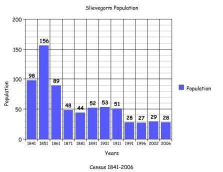
Census 1841-1851[9]
There were 19 households and 98 people living in Slievegorm in 1841 and this population increased to 156 people or 29 families in 1851. This population increase was the exception in the Parish of Killererin. Many townlands during the period 1841-1851, suffered dramatic declines in population due to emigration and death in the aftermath of the famine. The total area of land measured 125 acres, 1 rood and 0 perches with an annual valuation of £40 0s 0d.
Griffith’s Valuation 1855[10]
There were 13 named occupiers of land in Slievegorm in 1855 including John Donnelly who was named as occupying 3 plots all of these under 10 acres. The largest plots were occupied by James Kirwan who leased a house, offices and land measuring 23 acres, 2 roods and 31 perches from Michael J. Browne; George W. Bolton leased several plots of land as well as plots with houses and out-buildings the largest measuring 13 acres, 3 roods and 24 perches while Michael Connaughton leased 2 areas, the 1st with a house, offices and land measuring 10 acres, 3 roods and 8 perches and the 2nd area of land measuring 1 acre 3 roods and 3 perches.
Previously the land in this townland was owned by Lord Lorton. The Kings (the family name of the Lords Lorton), were granted over 23,000 acres of land in Connacht[11] in the 1600s, but by 1855 some of this land was owned by Michael J. Browne. Browne, who owned Moyne House, held large areas of land in Killererin and later in 1855, his estate was offered for sale under the Encumbered Estates Court. In 1857, Moyne house and over 1,000 acres of Browne’s estate was purchased by John Stratford Kirwan[12].
The smallest plots of land in this townland in 1855 were leased by Martin Nicholson, who leased a house and land from Browne measuring 1 acre, 0 roods and 10 perches and Ellen Wade who leased a house and land measuring just 24 perches. All occupiers leased their land from Browne. The largest annual valuation was on the plot occupied by George W. Bolton totalling £14 0s 0d.
Census 1861-1881[13]
There were 19 families or 89 people living in Slievegorm in 1861 and this figure decreased in 1871 to just 9 families and 48 people. This population decreased further in 1881 to 8 families and 44 people. There were 25 out-buildings listed in 1881. The total area of land in the townland measured 125 acres, 1 rood and 0 perches with an annual valuation of £52 15s 0d.
Census 1891[14]
There were 9 households and 52 people living in Slievegorm in 1891.
1901 Census[15]
There were 9 heads of family listed in the 1901 census for Slievegorm.
Devaney family
Martin Devaney aged 60 was married to Ellen aged 53. Martin and Ellen lived with their children; Patrick aged 22, Martin aged 19, Thomas aged 16 and Laurence aged 13.
Kirwan family
Patrick Kirwan aged 45 was married to Mary aged 40. Patrick and Mary lived with their children: Peter aged 18, Thomas aged 16, Honor aged 14, Delia aged 12, Kate aged 9, Hanna aged 7, Maggie aged 5, Ellen aged 3 and Celia aged 1.
Mulry family
Thomas Mulry aged 50 was married to Ellen aged 40. Thomas and Ellen lived with their children Margaret aged 18, Ellen aged 15, Honor aged 13, Bridget aged 9, Michael aged 7 and Patrick aged 5.
Hennelly family
John Hennelly aged 66 was a widower and lived with his son Patrick aged 39, his daughter Anne aged 20, his grandchildren Michael aged 8 and Mary aged 6. John’s son Patrick was also a widower.
Hurley family
Malachy Hurley aged 37 was a widower and lived with his sons: Edward aged 13, twins Patrick and John aged 11, Bernard aged 9 and Malachy aged 8.
Nestor family
Margaret Nestor aged 50 was a widow and lived with her children: John aged 30, Michael aged 26 and Mary aged 15.
Delaney family
Winifred Delaney aged 50 was married and lived with her son John aged 21.
Fahy family
Michael Fahy aged 34 was married to Norah aged 30. Michael and Norah lived with their children: Mary aged 5, Julia aged 4, Bridget aged 2 and Thomas who was under 1 year old.
Nicholson family
Martin Nicholson aged 40 was married to Margaret aged 40. Martin and Margaret lived with their children Michael aged 8, Mary aged 6 and Celia aged 3.
All of those listed recorded ‘Galway’ as their place of birth and all those of working age recorded their occupation as ‘farmer’ with the exception of John Hennelly who was a ‘shepherd’.
Property ownership and outbuildings
All occupants in the townland owned the land on which their houses were located, with the exception of Margaret Nestor, where the land was owned by John Nestor, probably her husband as Margaret was listed as a widow in 1901. At the home of John Hennelly, the land on which the house was located was owned by Patrick Gannon. There were 40 out-buildings listed in Slievegorm in 1901. The majority of homesteads recorded a stable, cowhouse, piggery, fowl-house and barn. However, Winifred Delaney held only a piggery and fowl-house. Martin Devaney was the only house to record a calf-house.
Youngest and oldest person in 1901
The youngest person in the townland in 1901 was Thomas Fahy who was less than 1 year old and the oldest person was John Hennelly, aged 66.
1911 Census[16]
As in 1901 there were 9 heads of household listed in 1911 including Martin Devaney, Margaret Nestor, John Hennelly, Malachy Hurley, Michael Fahy, Thomas Mulry, Martin Nicholson, Winifred Delaney and Patrick Kirwan all of whom were the heads of family listed in 1901. All of the occupants were again listed as ‘farmers’, with the continued exception of the Hennelly family who were ‘herds’.
A number of people married over 30 years
A number of people in the townland were married over 30 years including: Ellen and Thomas Mulry who were married for 35 years and had 9 children with 6 still living in 1911 which included Michael, aged 17 and Nora, aged 23.
Mary and Patrick Kirwan were married 30 years and had 10 children with 10 still living in 1911 including Thomas aged 25, Delia aged 22, Hannah aged 17, Maggie aged 15, Ellie aged 13, Celia aged 11, John aged 9 and Patrick aged 4.
Ellen and Martin Devaney were married 44 years and had 7 children with 5 still living in 1911 including: Patrick aged 31, Thomas aged 26 and Lawrence aged 23.
Winifred Delaney aged 68 was married for 34 years and had 4 children and 2 still living in 1911 including a son, John aged 30.
Land ownership
All of the occupants owned the land on which their homes were located, with the exception of John Hennelly where the land was owned by P. J. Gannon. There were 38 out-buildings listed in this townland in 1911, including 7 piggeries, 7 barns, 5 stables, 7 sheds, 3 fowl-houses and 9 cowhouses. John Hennelly and Winifred Delaney held only 2 out-buildings each. The youngest person in the townland was Mary Nestor aged 2 and the oldest was Martin Devaney aged 76.
Mapping Changes
The Ordnance Survey (OS) maps 1837-1842[18] show the townland situated near Horseleap crossroads[19] on the opposite side of Polladooey, on the main road from the village of Barnaderg. The inhabited area of the townland was situated in the centre, approached by a road from the south along the border with Dangan Beg. A lime kiln was located at the head of this road.
A comparison between the OS 25 inch Map 1888-1913[20] and the Aerial map 2005 gives a good indication of the changes in the landscape and geography of the townland. The 1888-1913 map shows the inhabited area in the centre of Slievegorm and the area to the north that was marshy or boggy ground.
The 2005 map shows that some houses remain in the centre of the townland and more have been built along the border with Dangan Beg in the south.
[1] Logainm.ie, ‘Placenames Database’, (http://www.logainm.ie/)
[2] Galway County Library, O’Donovan’s Field Name Book’, (http://places.galwaylibrary.ie/)
[3] ibid
[4] ibid
[5] PODUNK ‘Place Types and Land Allocation in Ireland’ (http://ei.epodunk.com/place-types.html) (June 2011) An Irish acre, the measure used from the 17th century, equalled 1.62 statute (English) acres, also called a plantation acre
[6] Galway County Library, O’Donovan’s Field Name Book’ (http://places.galwaylibrary.ie/)
[7] ibid
[8] National University of Ireland, Galway ‘Landed Estates Database’ (http://landedestates.nuigalway.ie)
[9] ‘Table VII –Area, Out-offices and Farm Steadings and Population together with the Valuation of Each Parish, Townland and Township of the County of Galway in 1881’ (James Hardiman Library, National University of Ireland, Galway, p.77)
[10] Ask About Ireland, ‘Griffith’s Valuation’, (http://www.askaboutireland.ie)
[11] National University of Ireland, Galway, ‘Landed Estates Database’ (http://landedestates.nuigalway.ie)
[12]ibid
[13] ‘Table VII –Area, Out-offices and Farm Steadings and Population together with the Valuation of Each Parish, Townland and Township of the County of Galway in 1881’ (James Hardiman Library, National University of Ireland, Galway, p.108)
[14] Census of Ireland for the Year 1911 [Province of Connaught, County of Galway] Area, Houses and Population, ‘Table VII-Area Houses Out-Buildings and Farm Steadings, and Population together with the Valuation of Each Poor Law Union, Dispensary District, Electoral Division, Townland in the County of Galway in 1911’ (Galway County Library, p101)
[15] The National Archives of Ireland, ‘Census of Ireland 1901/1911’ (http://www.census.nationalarchives.ie/search/results.jsp?census_year=1901&surname=&firstname=&county=Galway&townland=Slievegorm&ded=&age=&sex=&search=Search&relationToHead=&religion=&education=&occupation=&marriageStatus=&birthplace=&language=&deafdumb=&marriageYears=&childrenBorn=&childrenLiving=) (Aug 2011)
[16] The National Archives of Ireland, ‘Census of Ireland 1901/1911’, (http://www.census.nationalarchives.ie/)
[17] Kids Zone Learning with NECS ‘Create a Graph’, (http://nces.ed.gov/nceskids/createagraph/)
[18] Ordnance Survey Ireland, ‘25” Historical Map 1888-1913’ (www.osi.ie/pubicviewer) (Aug 2011)
[19] Horseleap Cross Roads is located in the townlands of Polladooey, Slievegorm and Brierfield.
[20] Ordnance Survey Ireland, ‘25” Historical Map 1888-1913’ (www.osi.ie/pub;icviewer) (Aug 2011)
No Comments
Add a comment about this page