Townland of Creevaghbaun
Heritage Committee & Moylough Parish Services Solas Scheme


Creevaghbaun, Craobhach Bán,[1] “white bushes”[2]
The townland of Creevaghbaun is situated in the Civil Parish of Killererin in the Barony of Dunmore. The townland is bordered on the north by Ahgloragh, in the south by the townland of Garraun, in the east by Cahernagry and in the west by the townland of Togher Beg. The Down Survey, a mapping survey carried out between 1656 and 1658 records the townland as ‘Owlter, Parish of ‘Killereran’’[3]. In Creevaghbaun in 1641 and in 1670, ownership of the townland was in the hands of the ‘Bishop of Tuam’.
According to O’Donovan’s Field Name Books 1830[4], early references to ‘Crwaghbane’ were found in the Chancery Inquisitions of James I (1603-1625). Reference is also made to ‘Creevaghbane’ in the Map of Property Surveyed in 1813 and 1814, to ‘Creevabawn’ in Larkin’s County Map of Galway 1819 and to ‘Creevaghbawn’ in the Boundary Survey Sketch Maps[5]. According to P.W. Joyce’s Place Names ‘Craobh’ [crave] signifies either a branch or a large wide-spreading tree. The name was given to large trees, under whose shadows games or religious rites were celebrated, or chiefs inaugurated; we may conclude that one of these trees formerly grew wherever we find the word perpetuated in a name. There are more than 30 townlands called ‘Creevagh’, i.e. branchy or bushy land.[6]
The property is described as the property of H.R. Henry, Esquire of England, including 292¾ acres ‘statute[7] measure and 135 acres of arable land’.[8] Henry also owned land in other parts of the parish including Addergoole, Ballynakilla, Barnaderg, Cloonconra, Cloonreddia, Cooldorragha, Carrowgorm, Cornacartan, Corralea, Corskeaghmore, Corskeaghbeg, Coolrevagh, Grange, Killeighter, Kilmore, Lisnaminaun, Lissavalley and Lissavalley Glebe.
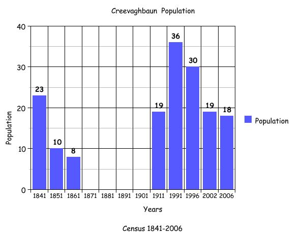
Census 1841-1851[9]
There were 3 households and 23 people living in Creevaghbaun in 1841 and this population decreased by over half to only 10 people living in 2 households in 1851. The total area of land in the townland was 150 acres, 2 roods and 22 perches with an annual valuation of £51 0s 0d.
Griffith’s Valuation 1855[10]
Hugh Henry retained all of the land in this townland for himself, including a house and land measuring 150 acres, 2 roods and 22 perches.
Census 1861-1881[11]
There were 2 households or 8 people living in the townland in 1861. Between 1871 and 1881 there are no recorded residents in the townland. In 1881 the total area of Creevaghbaun was 150 acres, 2 roods and 22 perches with an annual valuation of £65 0s 0d.
1891[12]
There were no residents in this townland in 1891.
Census 1901[13]
There is no record of any residents in Creevaghbaun in the census of 1901.
Census 1911[14]
There were 19 people living in Creevaghbaun in 1911.
Thomas Hynes aged 43 was married to Ellen aged 42 and they lived with their children: John J. aged 14, Mary D. aged 12, Katie aged 10, Margaret aged 9, Ellie aged 7, Norah aged 5 and Julia aged 5. In 1901 Thomas and Ellen both aged 33 lived in the townland of ‘Cornacarta’, Hillsbrook, in the house of Thomas’ parents, John aged 80 and Bridget aged 71. The grandchildren: John aged 4, Mary Delia aged 3 and Kate a newborn, also lived here in 1901.
Michael Donohoe aged 70 was married to Mary aged 71. They lived with their son Michael aged 25 and servant Peter Healy aged 17. A search of the census for Michael Donohoe revealed that in 1901, this man may have lived in Corskeagh, Hillsbrook. In 1901, a Michael Donohoe aged 60, his wife Mary aged 50 and his children included: Margaret aged 26, Patrick aged 22, Maria aged 19 and Michael aged 17.
Mary Donohoe was married for 36 years and had 6 children and 5 still living in 1911.
Peter Healy, mentioned above, aged 17 in 1911, may have been born in the townland of ‘Caheragry’, the son of Michael and Honor Healy.
Mary Flynn was a widow aged 55 who lived with her sons: Michael aged 33, Edward aged 25, Martin aged 19, Myles aged 11 and daughter Julia aged 15. In 1901, Mary lived in the townland of Kilmore, close to the townland of Creevaghbaun. Mary, who was aged 46 lived with her husband Peter aged 50 and their children: Ellen aged 19, Bernard aged 17, Edward aged 16, Peter aged 14, Maryanne aged 12, Martin aged 9, Julia aged 6 and Myles aged 1.
All of those listed, recorded their place of birth as Co. Galway and all had farming-related occupations.
There were 4 buildings listed on the House and Buildings Return in 1911. Mary Flynn, Thomas Hynes and Michael Donohoe all owned the land on which their houses were situated. A 4th house listed as sitting on land owned by William Gormelly, was uninhabited. All of the houses were of the 2nd class and had 3 front windows. In Mary Flynn’s home, 6 people occupied 4 rooms; in Thomas Hynes home, 9 people occupied 4 rooms and in Michael Donohoe’s house, 4 people occupied 4 rooms.
A number of out-buildings were also listed in 1911. Mary Flynn recorded 4 outbuildings, Thomas Hynes 2 out-buildings and Michael Donohoe had 5 out-buildings. All of the inhabitants had a piggery, while Michael Donohoe’s was the only household with a stable.
Census 1991-2006
The bar graph above plots the changes in population in this townland between 1841 and 2006 according to census information[15].
Mapping Change
The Ordnance Survey (OS) maps 1837-1842[1] show 2 ringforts in the area at the centre and southwest of the townland. A trigonometrical station was also located in the west. Directly east of this, Creevaghbaun Church (in ruins) and burial grounds were located. The neighbouring Holy Well and Sweat House (Teach Allais) are officially located in the townland of Kilmore. (However, locally today, the Sweat House is always referred to as being in Creevaghbaun). Towards the centre of the townland, a lime kiln was also situated.
A comparison between the 25 inch map 1888-1913 and the Aerial map 2005[2]shows how the landscape and geography of the area has remained the same. The 1888-1913 map, again shows the ringforts, church and burial grounds. An area in the south of Creevaghbaun is shown as boggy or marshy ground. There are no houses in this area, which borders northern Garraun, an area historically liable to flooding. The modern photographic map shows that 8 houses have been constructed along the main road, that is, the R332 close to the church and burial grounds. The south of Creevaghbaun remains free from housing or out-buildings of any kind.
The ruins of Creevaghbaun Church still remain and the burial ground is still used occasionally to the present day. The Church and Burial Grounds are located approximately 6.5km from Tuam on the right hand side of the road travelling towards Barnaderg North in a field about 200m off the road. The Church was built in 1332 by the De Burgo family and 400 years later the site was used as a restored Carmelite Convent[3].
An excavation conducted in 1989 showed the foundations at the north wall, and later work showed that a sacristy existed at the north end. According to the excavation Report, the interior of the church:
…measures 14.5m x 6.2m but some of its area is taken up by the tombs and crypts, built against the east gable and the south wall and these date to the early 19th century. Stray finds include fragments of clay pipe, iron slag and quern stone. Creevaghbaun Carmelite Friary was founded around the middle of the 14th century by the De Burgos[4].
Peter Harbison, writing in ‘A Thousand Years of Church Heritage in East Galway’, describes the church where there are unusually, 2 doorways, one each in the north and south walls. There are also a number of large vaults near the east of the church. There is an inscription beneath the window of the 2nd vault that says:
I.H.S. This tomb was erected for the rev. Frs. of Criuaughbane by ye Rev. Will Barry, Grand Nephew to ye Revd James Barry Foundr of sd Convent Anno Domino 1780[5]
Today the burial grounds are reached by a short lane from the main Tuam-Dublin Road.


Comments about this page
All my mother’s family are buried here, and it is still used by the family. It is an important place for us. Thank you for this page.
Thank you Bernadette , just seen your reply !
There were so many old abandoned buildings ( the old castle keep , RIC barracks etc it was a brilliant experience for a kid from Inner City London but the old graveyards are always fascinating.
Preserve your heritage ! Best wishes
I can remember exploring this cemetery many years ago ( 1959s/60s), as a small boy on holiday from England. At the time the site was untended.
Im certain there were gravestones dating from 1700/1800 s with my maternal family name – Mannion.
I there an index of those buried there ?
William
There is no index as yet. We have a record of some of the graves there but we haven’t started properly on that graveyard yet. We have three graveyards in the parish and the OLD CEMETERY as it is called is where we are working at the moment. If we come across any in the future I will email you directly. Lovely to hear from you. Bernadette
Add a comment about this page