Ardawarry


Location and origin
The townland of Ardawarry is situated in the west-central part of the Parish of Killererin, in the Barony of Clare, bordered on the west by the townlands of Cahergal and Barbersfort and on the east by Garraunbeg and Garraunmore and Carrowgorm. Clogherboy borders Ardawarry on the south. (Ard an Bharraigh meaning ‘Barry a Norman surname)’. According to O’Donovan’s Field Name Books 1830, early references are made to this townland as ‘Ardawarry’ in the Boundary Survey Sketch Map surveyed in 1813-1814. Another authoritative source, Pat Jennings, Proprietor’s Tenant, cited the spelling of the townland as ‘Ardaworry’[2]. The townland was the property of R.W. Ruttledge, Esquire, Dublin and contained ‘138¼ acres stature measure including about 10 acres of rough rocky ground and about 8 acres of bog’[3].
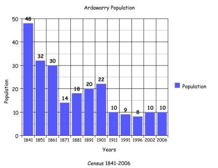
1841- 1851 Census[4]
There were 6 households and 48 people living in Ardawarry in 1841. These 6 households continued to be inhabited up to 1851, although the population decreased to 32 people.
Griffith’s Valuation 1855[5]
There were 8 landholders named in Griffith’s Valuation holding a total of 138 acres, 3 roods and 26 perches. David Ruttledge owned the land; he lived in Barbersfort House and leased the land to Francis Raftery, Francis Mannion, Luke Fahy, Thomas Hession, Francis McDermott, John Fahy and Mark Connolly. David Ruttledge retained 66 acres, 1 rood and 28 perches for his own use.
1861-1881 Census[6]
There were 30 people living in 4 houses in this townland in 1861. By 1871 there were 14 people living in 3 houses. By 1881 there were still 3 houses and the population had increased to 18 people.
1891 Census[7]
In 1891 there were 20 people residing in 3 houses in the townland.
1901 Census[8]
There were 3 houses recorded for this townland in the 1901 census.
Moran family
Honor Moran aged 62, was a widow and a farmer. Her son John aged 40 and daughter-in-law, Ellen also aged 40, lived with her as did her 8 grandchildren: Norah aged 14, twins Patrick and Bridget aged 11, Mary aged 9, Kate aged 8, Thomas aged 6, Winifred aged 4 and James aged 3.
Mannion family
Thomas Mannion aged 51 and a farmer lived with his wife Honor aged 45 and their children, Mary aged 15, John aged 13, Margaret aged 11 and Catherine aged 10 years.
McDermott family
Michael Mc Dermott aged 47, a farmer lived with his wife Julia aged 45. They had 3 children John F. aged 16, Maggie T. aged 11 and Julia A. aged 9 years.
Property type
These were all recorded as second-class houses; all had thatched roofs and 3 windows to the front.
1911 Census[9]
By 1911 there were still 3 houses inhabited in this townland. Michael Mc Dermott aged 67 and his wife, Julia aged 68, occupied 1 residence. They were married for 29 years, had 4 children with 2 still living in 1911.
Moran family
Ellen Moran, aged 54 was a widow and lived with her 4 children, Patrick aged 21, Katie aged 18, Thomas aged 16 and Winifred aged 14 years.
Mannion family
Honor Mannion was a widow and she lived with her son, John aged 24 and her daughter, Catherine aged 20 years.
1991-2006 Census[10]
In 1991 there were 9 people living in 3 houses. By 1996 there were 4 houses and 8 in population. In 2002 there was an increase to 5 houses and 10 in population. It is interesting to note that from 1841 to 2006 there was a decrease of 25% in the population.
Mapping Changes
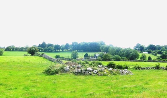
The OS 1842 map[11] shows Ardawarry as a boomerang shaped townland. There were no dwellings in the north or south of the townland. A bed of stones existed in the east of Ardawarry close to the border with Garraun Beg. Directly west of this, a number of houses were located along the western border with Barbersfort. The land furthest north in the townland was boggy/marshy ground.[12]
Mapping changes
A comparison between the earlier OS 25” Map (1888-1913) and the later OS Aerial Map 2006 shows how the landscape and geography of the area has changed (and indeed, some aspects have remained the same). In the 1888-1913 Map, a quarry-type area was visible close to the bed of stones mentioned above. A small road or lane travelled just to the south of this, in a north-westerly direction through Barbersfort towards the river in the west. In the north, a sheepfold and a limekiln were located. On the OS map 1811-1913, the houses mentioned earlier in the west were fewer in number. By 2005 the same area in the west along the road bordering Barbersfort are the sites of the present day houses. Much of the townland in the present day is farmland.
[1] Placenames Database of Ireland (www.logainm.ie) (May2011)
[2] Galway County Library, ‘O’Donovan’s Field Name Books’ (www.place.galwaylibrary.ie) (March 2011)
[3] ibid
[4] Table V11-Area, Out-Offices and Farm Steadings and Population together with the Valuation of Each
Parish, Townland and Township of the County of Galway in 1881’ (James Hardiman Library, National University of Ireland, Galway, p.20 (March 2012)
[5] Ask About Ireland, ‘Griffith’s Valuation’ (www.askaboutireland.ie/griffith-valuation) (Feb 2011)
[6] ‘Table V11-Area, Out–Offices and Farm Steadings and Population together with the Valuation of Each Parish, Townland and Township of Galway in 1881’, (James Hardiman Library, National University of
Ireland, Galway, p38) (May 2011)
[7]Census of Ireland for the Year 1911[Province of Connaught, County of Galway] Area, Houses and Population, ‘Table VII-Area Houses Outbuildings-Buildings and Farm Steadings, and Population together with the Valuation of Each Poor Law Union, Dispensary District, Electoral Division, Townland in the County of Galway in 1911’ (Galway County Library, p110)
[8] National Archives of Ireland, ‘Census of Ireland 1901/1911’ (www.census.nationalarchives.ie)(Feb 2011)
[9] ibid
7Central Statistics Office, (www.cso.ie/census/reports) (May 2011)
[11] Galway County Library, ‘1842 Ordnance Survey Maps’
(http://places.galwaylibrary.ie/maps) (Jan 2012)
[12] Ordnance Survey Ireland, (www.osi.ie/mapviewer) (Jan 2012)
No Comments
Add a comment about this page