Pollacappul


Pollacappul, Pol an Chapaill,[1] “(water) hole of the horse”[2]
The townland of Pollacappul is situated in the Civil Parish of Killererin in the Barony of Clare. The townland is bordered on the north by the townland of Corskeagh More, on the south by Barnaderg North, the east by Omaunbeg and on the west by the townland of Cahernagry. The Down Survey, records the townland as ‘Knocknadrough’, Parish of ‘Killereran’[3]. In Pollacappul in 1641, the owners were listed as ‘Richard Bourke (Catholic)’ and in 1670 ‘Martin Kirwan (Protestant)’.
O’Donovan’s Field Name Books
According to O’Donovan’s Field Name Books 1830,[4] early references to this townland were cited as ‘Pollaghcappull’ and ‘Pollecapuill’ found in the Chancery Inquisitions of James I (1603-1625) and ‘Pollychappull’ in the Chancery Inquisitions of Charles I (1625-1949). Other forms of the name cited by O’Donovan were recorded as ‘Pollacapple’ and ‘Poll a Chapuill’. The Boundary Survey Sketch Maps[5], cited the spelling of the townland as ‘Pollacapple’. Today, locally the townland is spelled, ‘Pollacappul’.
Property of H.R. Henry Esquire, England
The townland was described as the property of H. R. Henry, Esquire, England. It contains 219¾ acres statute measure[6], including 90 acres of bog and the remainder arable land’[7]. Henry held land in other townlands in the parish of Killererin including Addergoole, Ballynakilla, Barnaderg, Carrowgorm, Cloonconra, Cloonreddia, Cooldorragha, Coolrevagh, Cornacartan, Corralea, Corskeaghbeg, Creevaghbane, Grange, Killeighter, Kilmore, Lisnaminaun, Lissavalley, Lissavalley Glebe, Omaunbeg, Omaunmore, Pollaun, Shantallow, Tigreenaun, Togherbeg and Toghermore.
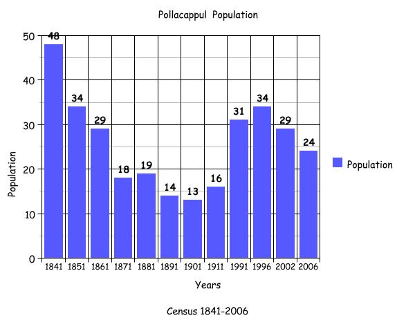
Census 1841-1851[8]
There were 48 people living in 8 houses in this townland in 1841. This figure decreased to 34 people in 1851 living in 6 houses. The total area of the townland in 1851 was 219 acres, 0 roods and 37 perches with an annual valuation of £36 0s 0d.
Griffith’s Valuation 1855[9]
A total of 11 people held land in Pollacappul in 1855 including Hugh Henry who retained 83 acres, 0 roods and 1 perch of bog for himself at an annual valuation of 5s 0d. The remaining 10 land- holders leased their holdings from Henry at a total valuation of £46 10s 0d. Richard Burke leased land measuring 3 acres, 0 roods and 10 perches; Michael Healy leased land measuring 3 roods, 20 perches; Martin Healy leased land measuring 3 acres, 0 roods and 31 perches; John Fahy leased land measuring 1 acre, 0 roods 22 perches and John Healy leased a house, offices and land measuring 16 acres, 3 roods and 21 acres.
Multiple plots held by some landowners
Further multiple plots were also held by Martin Donnellan who leased 3 plots; the 1st of land measuring 5 acres, 3 roods and 2 perches, the 2nd of land measuring 15 acres, 0 roods and 20 perches and the 3rd of a house, offices and land measuring 23 acres, 3 roods and 15 perches. Patrick Forde leased 2 plots; the 1st of a house and land measuring 8 acres, 2 roods and 0 perches and the 2nd measuring 5 acres, 0 roods and 5 perches. Michael Costello leased 3 plots: the 1st of land measuring 6 acres, 3 roods and 10 perches; the 2nd of land measuring 6 acres, 1 rood and 18 perches and the 3rd of a house, offices and land measuring 1 acre, 2 roods and 10 perches. James Costello leased 3 plots; the 1st of land measuring 5 acres, 3 roods and 33 perches, the 2nd of land measuring 6 acres, 1 rood and 39 perches and the 3rd of a house, offices and land measuring 1 acre, 3 roods and 36 perches. Finally Michael Leary also leased 3 plots; the 1st of land measuring 7 acres, 0 roods and 35 perches, the 2nd of land measuring 7 acres, 3 roods and 2 perches and a 3rd of house, offices and land measuring 1 acre, 1 rood and 12 perches.
Census 1861-1881[10]
There were 29 people living in 8 houses in Pollacappul in 1861 and this population decreased to 18 people living in 3 houses in 1871. In 1881, there were 19 people living in 3 houses. The area of the townland in 1881 was 219 acres 0 roods and 37 perches with a valuation of £45 7s 0d.
Census 1891[11]
There were 2 households and 14 people living in Pollacappul in 1891.
Census 1901[12]
There were 13 people or 2 families living in Pollacappul in 1901 namely the Healy and Cassidy families. Mary Healy, aged 55 was a widow and lived with her sons: John aged 33, Dennis aged 30, Michael aged 25 and James aged 20.
The Cassidy family
The head of the Cassidy family was Celia Cassidy, a married woman aged 32. Celia lived with her children: Margaret aged 16, Delia aged 15, Mary aged 13, Patrick aged 12, Ellen aged 10, John, aged 8 and Sarah aged 3.
Occupants all from Co. Galway
All the occupants in this townland in 1901 recorded their place of birth as Co. Galway and all were recorded as farmers. None of the adult children of these families were married in 1901.
Oldest and youngest person in the townland
The oldest person in this townland in 1901 was Mary Healy aged 55 and the youngest was Sarah Cassidy aged 3.
Census 1911[13]
There were 16 people or 4 families living in Pollacappul in 1911. As in 1901 the Healy and Cassidy families were recorded, this time the head of the Cassidy family was listed as Thomas, a farmer aged 60. Thomas and Delia were married for 29 years and had 7 children in total and 7 still living in 1911.
Mary Healy
Mary Healy was a widow and was listed as head of family in the Healy house.
The Mannion family & Norah Farrell
The 3rd family, the Mannion family was headed by William aged 31. He was a farmer who was married to Mary for 1 year in 1911. This couple had 1 child Martin who was less than 1 year old in 1911. William’s sister-in-law Norah Farrell aged 10 also lived in this house.
The Cassidy family
A 4th family was headed by Mary Cassidy who was a widow aged 55. Mary lived with her children Thomas aged 24, Michael aged 20 and Margaret aged 16.
All occupants of townland were from Co. Galway
All of the occupants of this townland recorded their place of birth as Co. Galway with the exception of Mary Mannion, married to William who was born in Co. Limerick, as well as her sister Norah Farrell who was also born in Limerick. All occupations in this townland were recorded as ‘farmer’ or ‘scholar’.
Type of houses
There were no 1st class houses in the townland in 1911. Mary Healy, William Mannion and Mary Cassidy lived in 2nd class houses with 2-3 front windows, while Thomas Cassidy lived in a 3rd class house with 2 front widows. All of the occupants of houses in Pollacappul owned the land on which their homes were located.
Outbuildings in townland
As well as dwellings, a number of out-buildings were recorded: the Healy family had a stable, cow-house, piggery and barn. Thomas Cassidy had a stable, cowhouse and piggery. The Mannion family had a cowhouse, fowl-house and barn and Mary Cassidy had a stable, cowhouse, piggery, fowl-house and barn.
Oldest and youngest person in the townland
The oldest person in Pollacappul in 1911 was Mary Healy aged 72 and the youngest was Martin Mannion who was less than 1 year old.
Census 1991-2006
The adjacent bar graph plots the changes in population in this townland between 1841 and 2006 according to census information.[14]
Mapping Change
The Ordnance Survey (OS) ap (1837-1842)[15] shows that all of the dwellings in this townland were in the south, located along a small road just off the main road towards Tuam, with the exception of 1 house located on this main road near the south-western border with Cahernagry. There were approximately 16 buildings in the townland in the early 1840s with a lime kiln at the centre of the main grouping of houses. A well was also located in the southeast of Pollacappul.
A comparison between the OS 25 inch map 1888-1913[16] and the OS Aerial map 2005[17] shows how the landscape and geography of the area has changed. The 1888-1913 map shows 2 disused gravel pits in the townland in the east and southeast. There were also 2 springs located in the east and centre of Pollacappul, as well as a lime kiln. In 2000 and 2005 the northern portion of this townland was bog/marsh ground while the southern portion was farmland. As with the historical map, the modern photo shows that all of the dwellings are located in the south.
[1] Logainm.ie, ‘Placenames Database’, (http://www.logainm.ie/)
[2] Galway County Library, ‘O’Donovan’s Field Name Books’ (http://places.galwaylibrary.ie/)
[3] Trinity College, Dublin, ‘The Down Survey’ (http://downsurvey.tcd.ie/)
[4] Galway County Library, ‘O’Donovan’s Field Name Books’ (http://places.galwaylibrary.ie/)
[5] ibid
[6] PODUNK ‘Place Types and Land Allocation in Ireland’ (http://ei.epodunk.com/place-types.html) (June 2011). An Irish acre, the measure used from the 17th century, equalled 1.62 statute (English) acres, also called a plantation acre
[7] Galway County Library, ‘O’Donovan’s Field Name Books’ (http://places.galwaylibrary.ie/)
[8] ‘Table VII –Area, Out-offices and Farm Steadings and Population together with the Valuation of Each Parish, Townland and Township of the County of Galway in 1881’ (James Hardiman Library, National University of Ireland, Galway, p39)
[9] Ask about Ireland, ‘Griffith’s Valuation’ (http://www.askaboutireland.ie/griffith-valuation/index) (May 2011)
[10] ‘Table VII –Area, Out-offices and Farm Steadings and Population together with the Valuation of Each Parish, Townland and Township of the County of Galway in 1881’ (James Hardiman Library, National University of Ireland, Galway, p39)
[11] Census of Ireland for the Year 1911 [Province of Connaught, County of Galway] Area, Houses and Population, ‘Table VII-Area Houses Out-Buildings and Farm Steadings, and Population together with the Valuation of Each Poor Law Union, Dispensary District, Electoral Division, Townland in the County of Galway in 1911’ (Galway County Library, p110)
[12] The National Archives of Ireland, ‘Census of Ireland 1901/1911’ (http://www.census.nationalarchives.ie/)
[13] ibid
[14] Kids Zone Learning with NECS ‘Create a Graph’, (http://nces.ed.gov/nceskids/createagraph/)
[15] Ordnance Survey Ireland, ‘25” Historical Map 1888-1913’ (www.osi.ie/pub;icviewer) (May 2011)
[16] ibid
[17] ibid
No Comments
Add a comment about this page