Shantallow, Sean Talamh, “old land”[1]


Location
The townland of Shantallow is in the Civil Parish of Killererin. It is situated in the northwest extremity of the parish in the barony of Clare. It is bordered on the north by Toghermore, and on the east by Ballynakilla and on the south and west by the parish of Cummer. According to O’Donovan’s Field Name Books 1830, early references are made to the spelling of this townland as ‘Shantalla’. The Map of Property surveyed in 1813-1814 refers to ‘Shantalla’ and William Larkin’s Map of Galway 1819 refers to ‘Shantholla. This reference also appears in the Boundary Survey Sketch Maps[2]. The townland was the property of H.R. Henry, Esq., England and it contained 287 ½ acres statute measure including about 90 acres of bog[3] .
Census 1841-1851[4]
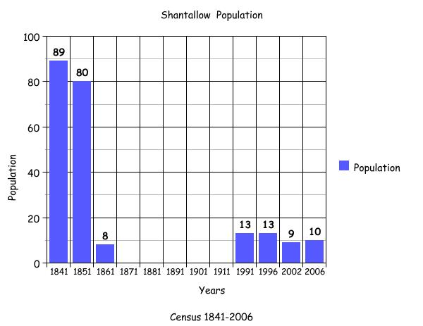
There were 15 households and 89 people living in Shantallow in 1841. There were 12 households and a decrease in population to 80 people by 1851. The total area of land in the townland was 287 acres 2 roods and 14 perches with an annual valuation of £80 0s 0d.
Griffith’s Valuation 1855[5]
There were no occupants listed in this townland in Griffith’s Valuation in 1855. This townland seems to have suffered the effects of the famine with the disappearance of all the residents during this period.
Census 1861-1881[6]
There was 1 house and a population of 8 in the townland of Shantallow in 1861. During the years of 1871-1881 there were no people living in the townland.
Census 1891[7]
There were no houses or people listed in the townland in 1891.
1901 – 1911 Census[8]
There were no residents living in this townland at this time.
1991-2006 Census
In 1991 there were 2 houses with a population of 13 in this townland. The number of houses and population remained the same during 1996. By 2002, the number of people had decreased to 9 with the number of houses remaining at 2. In 2006, the population increased to 10 with the number of houses still remaining at 2. The graph above shows the changes in population in this townland between 1841 and 2006 according to census information.
Mapping Change
On the OS Map 1837-1842 there is evidence of the ruins of a ‘Gobán Saor’s house’ and a burial ground both to the east end of the townland.[9] A Gobán Saor was a mason and a smith. He was supposed to have been a “master of all things”. He was also very witty and could tell stories, sing and recite poetry[10].
Ancient fort
A cluster of buildings can be seen on this map to the northwest of the burial ground. There was an ancient fort of an unusual size to the east of the burial ground. On the OS map 1888-1913, a lime-kiln is recorded to the west of the burial ground and a well to the north. There was a herd’s house and out-offices recorded in this map also. Today, there is a residence on that same plot of land. This house is located alongside a road that travels through Togher and leads on to the main Dublin Road.[11]
[1] Irish Placenames Database, (www.logainm.ie) (March 2011)
[2] Galway County Library, O’Donavan’s Field Name Books’ (www. places.galwaylibrary.ie (March2011)
[3] ibid
[4] Table V11-Area, Out-Offices and Farm Steadings and Population together with the Valuation of Each Parish, Townland and Township of the County of Galway in 1881’ (James Hardiman Library, National University of Ireland, Galway, and p.39 (March 2012)
[5] Ask about Ireland, ‘Griffith’s Valuation’ (http://www.askaboutireland.ie/griffith-valuation/index). (March 2012)
[6] Table V11-Area, Out-Offices and Farm Steadings and Population together with the Valuation of Each Parish, Townland and Township of the County of Galway in 1881’ (James Hardiman Library, National University of Ireland, Galway, and p.39 (March 2012)
[7] Census of Ireland for the Year 1911[Province of Connaught, County of Galway] Area, Houses and Population, ‘Table VII-Area Houses Outbuildings-Buildings and Farm Steadings, and Population together with the Valuation of Each Poor Law Union, Dispensary District, Electoral Division, Townland in the County of Galway in 1911’ (Galway County Library, p110)
[8] National Archives of Ireland, ‘Census of Ireland 1901/1911’ (www.census.nationalarchives.ie) (March 2011).
[9]Ordnance Survey Ireland, (www.osi/publicviewer) (Feb 2012)
[10] The Kiltartan History’, (www.fullbooks.com) (March 2011)
[11] Ordnance Survey Ireland, (www.osi/publicviewer) (Feb 2012)
No Comments
Add a comment about this page